Flood risk management annual report 2024 to 2025
Foreword
This Annual Report summarises the range of activities undertaken by Natural Resources Wales in managing the risks from flooding in Wales, in 2024/25.
The winter once again gave us several named storms, with Storms Bert and Darragh in particular causing significant impacts in Wales, and once again stretching the capacities of the responder organisations. Whilst it is right to acknowledge the absolute misery that flooding causes to communities and to people, and express deep sympathies to those impacted, we must also acknowledge the dedication and professionalism of staff from across the sector who do their utmost to manage the risks in the first place, and who respond when storms and floods hit. It is not an easy task, but it is a really important one, and one that makes a difference.
This report once again shows the breadth and depth of the work that goes in to manage the risks from flooding. Every element is important, and there are links between all elements – the whole is needed and nothing is in isolation. For example, you can’t manage the risks from flooding if you don’t understand the risks; the mapping and modelling of flood risks is hugely important and feeds the prioritisation and delivery of all of our flood risk management work. It is also used by other organisations for their delivery, and is a crucial part of the information for the public on where and what is at risk of flooding.
Another example is we cannot issue flood warnings without the whole supply chain from rainfall and river flow data, which itself needs the rain gauges and river gauging stations with the data feeds sent back to base to access and process the data, then the models that we use to forecast, and the complex ICT systems to issue the warnings. Then, there needs to be information and advice as to what communities and individuals actually should do if and when they get a warning – the warnings need to be understood and acted on. It requires a whole chain of activities, systems, and – crucially – expertise from our staff.
This area of warning and informing the public of flood risk is a hugely important element of what we do. It is impossible to stop all flooding, and having accurate and timely flood warnings is a core element of mitigating the impacts of flooding. In 2024/25, we delivered our new Flood Warning Information System for Wales; a £5m multi-year project that replaced the previous flood warning system. We also advanced our project to replace the ageing Telemetry system, which is due for roll out later in 2025. I highlight these two as essential elements of investment that can often go unmentioned, when the public clamour can often be for flood defences. I think of the absolutely devastating floods in Valencia in October 2024 and the questions asked there about investment in emergency planning and flood warnings. It is no exaggeration to say it really can be a matter of life and death.
Meanwhile, flood risks are increasing; it is not a static concept. Investment is needed in all the aspects of flood risk management in this report, and in other new approaches too as they emerge, if we are going to be able to manage down the risks appropriately. It is no doubt challenging times, but the evidence in this report shows the extent and quality of the work that staff across NRW, and partner organisations too, are doing in response. My thanks and recognition go to them all.
Jeremy Parr
Head of Flood and Incident Risk Management
Natural Resources Wales
Executive summary
Natural Resources Wales (NRW) is the largest Welsh Government Sponsored Body, and we have as our core purpose the sustainable management of natural resources in Wales.
We have a range of roles and responsibilities, ranging from regulator to advisor, landowner and operator and emergency responder. We have a strategic oversight role for flood and coastal erosion risk management which involves the general supervision and communication of flood and coastal erosion risk management in Wales. We also have powers to manage flooding from main rivers, reservoirs, and the sea.
In Wales, there are estimated to be 275,000 properties at risk of flooding. This is approximately 1 in 7 properties in Wales. We take a risk-based approach to managing the risk of flooding through the activities we do. This report summarises the investment, key activities, and achievements in managing flood and coastal erosion risks across Wales by NRW for the financial year from April 2024 to March 2025. It is based on the best available information at the time of writing (Spring/summer 2025).
We intend to use this annual report to form part of the statutory report that we have a duty to undertake (under Section 18 of the Floods and Water Management Act) on progress of the implementation of Welsh Government’s Flood and Coastal Erosion Risk Management Strategy. The Strategy was published in October 2020, and many of the activities described in this annual report contribute toward the delivery of the objectives and measures included within that Strategy.
Some of key highlights from 2024/25 include:
- Investment of £47m of Welsh Government funding on key flood risk management activities.
- The completion of the significant Stephenson Street flood alleviation scheme in Newport that reduces the flood risk to 1,032 properties. We have also completed a scheme at Sandycroft, Flintshire (218 properties).
- A further 856 properties directly benefitted from the ongoing sustained level of flood protection provided by our capital maintenance work.
- Continued working towards delivery of measures from the Welsh Government Flood and Coastal Erosion Risk Management Strategy.
- Delivery of improvements to our prioritisation of our routine asset maintenance programmes through the introduction of a new risk based approach.
- Delivery of our System Asset Management Plan that will help us to take an integrated approach to the management of FRM assets.
- Delivery of our new £5m Flood Warning Information Service for Wales which de-couples us from the previous England and Wales service and allows us to better respond to the needs of customers in Wales in the future.
- Delivery of our #BeFloodReady campaign and flood volunteer network events.
- Continued development of key £5m ICT projects to replace our Telemetry system.
- Continued our work with our partners on the joint Reservoir Safety Reform Programme to develop a set of new proposals on reservoir safety.
Further information on all of these highlights, plus other key achievements, is included in this report.
Introduction
This annual report details our key achievements and deliverables for flood and coastal erosion risk management for the financial year 2024/25. It provides detail on the activities that contribute towards the management of flood risk in Wales and also highlights key metrics and statistics which demonstrate the level of effort that goes into managing flood risk and the scale of the challenge faced.
This report does not cover every activity or service area in detail and is intended as a summary of the 2024/25 financial year highlights. The information and data presented in this report is based on data available at the time of producing this summary (spring/summer 2025). This report is a recurring annual publication and will complement the delivery of the next progress report on the Welsh Government Flood and Coastal Erosion Risk Management Strategy (the ‘Section 18 report’, required under Section 18 of the Floods and Water Management Act).
Storms and flooding experienced over the past year (April 2024 – March 2025)
Each year, we plan the work we want to deliver to manage flood risk. On top of that, we must respond to flood events when they happen. Our response may be reactive to manage the flood event at the time, or it may generate additional work that we need to deliver. This section provides a summary of the more notable flooding and storm events during the year that we responded to, including those that caused significant disruption or damage to communities.
We monitor and respond to floods whenever they happen - 24 hours a day, 7 days a week, 365 days a year. This includes tracking forecasts, issuing warnings, ensuring flood and hydrometry assets are operating properly, posting up-to-date information on our website, handling media interviews and queries, supporting other incident responder organisations and fixing damage caused to defences after storms. When an event occurs it clearly impacts our ability to deliver other planned work as we react to the challenges each severe weather event introduces, both during and in the period following these events, as we deal with the impacts and the aftermath.
Storms 2024/25
As this report covers the financial year from April 2024 to March 2025, it covers two storm seasons. Storm seasons run from September to the following August. Whilst unusual to get named storms between April and August in any given year, in 2024, there were two, which were part of to the 12 named storms for the 2023/24 storm period. This was the first time the UK had so many named storms in a storm season since storm naming began in 2015. For the 2024/25 storm season that is still happening at the time of writing this report, to date there have been 5 named storms, with storms Bert and Darragh leading to the most significant impacts in Wales. There were 7 named storms in the financial year covered by this report.
The section below describe the storms that had impacts in Wales.
Storm Kathleen, 6 to 7 April 2024
Storm Kathleen was an unusually severe storm for the time of year with very strong winds, especially in coastal areas which also coincided with a period of springs tides, and heavy rain. The stormy conditions particularly affected the Western and Northern parts of Wales where we issued several Flood Warnings in response to the poor conditions on the coast. 35 properties experienced internal flooding.
Storm Lilian, 22 to 23 August 2024
Storm Lilian was the 12th and final storm of 2023/24 storm season and the first time named storms reached the letter L in any storm season. Storm Liliam was the most significant August windstorm to affect the UK since storms Ellen and Francis in August 2020. Strong winds affected coastal areas around Wales leading to Flood Warning and Flood Alerts to be issued.
Storm Ashley, 20 to 21 October 2024
Storm Ashley was the first storm of the 2024/25 storm season and bought heavy rain and very strong winds across Wales but mostly impacting coastal areas and communities. Sea flooding was experienced around the coast including in coastal communities Borth, Amroth and Aberystwyth.
Storm Bert, 22 to 25 November 2024
Over the weekend of the 23 to 24 November 2024, storm Bert brought a period of very wet and windy weather to Wales. There were widespread rainfall totals of 50 to 100mm across Wales with over 150mm of rain in the wettest upland areas. In many places in South Wales, the rainfall amount in the three day period from 22 to 24 November was 70% or above of the November average rainfall. 23 November was the wettest day in the UK since October 2020 and the 12th wettest in the UK series from 1891. This amount of rainfall falling on already wet catchments led to some rivers in South Wales reaching their highest ever recorded levels.
Figure 1: River levels recorded for River Taff at Pontypridd during Storm Bert (the line for highest recent recorded was from Storm Dennis in 2020)
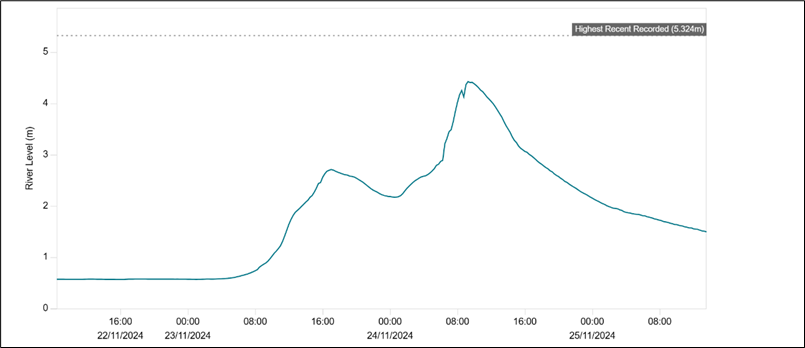
During Storm Bert more than 700 homes across Wales experienced flooding, with Pontypridd, which was badly affected during storm Dennis in 2020, again one of the most severely affected communities. A landslip occurred at Cwmtillery, Blaenau Gwent, with a disused coal tip partially collapsing, forcing the evacuation of around 40 homes due to rock and mud flowing onto residential streets. In addition, a large sinkhole opened on a residential street in Merthyr Tydfil after an underground culvert was damaged by boulders.
As a result of Storm Bert, flooding and infrastructure damage led to widespread disruption of railways, including the closure of the Heart of Wales and Marches lines. Many roads were also closed due to flooding and landslides, including the A479 in Powys and the A4042 in Monmouthshire.
Within the collective efforts from a range of organisations, NRW staff worked tirelessly throughout this period, using their skills and experience to professionally respond to events. Our staff worked to track forecasts, issue warnings, ensure flood hydrometry assets were operating properly, fix repairs, post up to date information on our website and social media pages, handle media interviews and queries and support other incident responder organisations including Local Authorities, emergency services and utility companies.
Storm Darragh, 6 to 7 December 2024
Storm Darragh bought very strong winds to West Wales and coastal areas along the South Wales coastline resulting in a rare red weather warning being issued by the Met Office. The UK Government also issued an emergency alert by phone to those affected areas. This was the first time this system had been used since being introduced in 2023.
Storm Darragh arrived just two weeks after storm Bert so the risk of flooding was also a concern as storm Darragh bought 50 to 100mm of rain to upland areas of Wales on already saturated catchments. There was widespread travel disruption, damage to buildings and infrastructure. The destructive winds significantly damaged power infrastructure with more than 259,000 homes without power at the peak of electricity network disruption. Although we issued 110 flood alerts and 41 flood warnings throughout the duration of storm Darragh, flooding impacts were, thankfully, not widespread. There was however much damage to NRW’s woodland estate with large areas of trees fallen in widespread areas across Wales as well as damage to forest roads, access tracks, walking trails and mountain bike routes.
Flood risk management improvement programme
Our FRM service seeks to reduce flood risk to the communities of Wales through a range of activities across the business covering operational and policy driven work. To support this work, a strategic Flood Risk Management Improvement Programme was established in January 2020. The improvement programme is structured to ensure all project work outside of construction projects or ‘business as usual’ activity is centralised in a single programme bringing transparency, consistency, and effectiveness in identifying and delivering improvements and efficiencies across the service. The aim of our programme is to continuously improve to ensure a more resilient service for the future.
At the end of March 2025 there were 16 live projects within the programme. Over the last year a number of projects have been completed, including the Risk Based Revenue Allocation Model (RBRAM) project, Improving the understanding and accessibility of the Community at Risk Register project and (ICT) Flood line - Welsh Language Call Transfer project. Many of the projects from the FRM Improvement Programme feature in the relevant topic chapters in this annual report.
This programme now also contains the remaining Flood Recovery & Review Implementation Programme Actions that were transferred to this programme in April 2024. In total there were 12 actions transferred to this programme to be completed by the end of 2025. As of the end of March 2025, 4 have been completed and signed off. While the majority of the remaining 8 actions are on track to complete as forecasted, two are likely to be delayed until 2026/27 due to the dependencies on resources and ICT delivery routes not being secured.
Understanding and analysing flood risk
This work area includes all efforts to increase the understanding we have of flood risk in Wales, mainly through our hydrological analysis and flood risk modelling activities. It also includes how we communicate that flood risk to stakeholders through our flood mapping products and website services. Its purpose is to increase our understanding of flood risk, to inform and advise all our other activities, and to inform stakeholders of their relevant flood risk.
We have powers to manage flooding from main rivers, our reservoirs, and the sea. We also have a strategic oversight role with general supervision over all Flood and Coastal Erosion Risk Management matters. This is about having a Wales-wide understanding of all sources of flooding, coastal erosion and the risks associated with them, on a consistent basis to provide advice to the Welsh Government as well as helping inform risk management authorities and the public. As part of our oversight role, we undertake national flood and coastal erosion risk mapping for all sources of flood risk.
What’s at risk of flooding in Wales now?
As of April 2025, the undefended sum of properties at risk of flooding in Wales is 342,436. Some properties may be at risk from more than one source and therefore removing any double or triple counting of properties at risk from multiple sources there are over 274,000 properties are at risk of flooding in Wales. Tables 1 to 3 below show the breakdown by flood source, type of property and flood risk band.
We have made improvements to our knowledge and understanding of flood risk which has led to changes in the way in which we model and calculate properties at risk of flooding. This, along with including static caravans in our counts for the first time, has led to numbers of properties at risk of flooding increasing since the last major update was performed.
The following tables show the split of properties by level of risk and source, correct as of April 2025.
Table 1: The numbers of residential properties, non-residential properties, and services at risk of flooding in Wales from rivers.
| Flood risk description | Residential properties at risk of flooding | Non-Residential properties at risk of flooding | Key Services* at risk of flooding | Total at risk of flooding |
|---|---|---|---|---|
| Rivers High | 25,126 | 3,074 | 787 | 28,897 |
| Rivers Medium | 17,172 | 2,528 | 486 | 20,186 |
| Rivers Low | 48,409 | 6,988 | 1,361 | 56,758 |
| Rivers Total | 91,102 | 12,630 | 2,745 | 106,477 |
Table 2: The numbers of residential properties, non-residential properties, and services at risk of flooding in Wales from the sea.
| Flood risk description | Residential properties at risk of flooding | Non-Residential properties at risk of flooding | Key Services* at risk of flooding | Total at risk of flooding |
|---|---|---|---|---|
| Sea High | 56,759 | 5,913 | 1,194 | 63,866 |
| Sea Medium | 13,638 | 2,097 | 458 | 16,193 |
| Sea Low | 9,884 | 1,429 | 335 | 11,648 |
| Sea Total | 80,281 | 9,439 | 1,987 | 91,707 |
Table 3: The numbers of residential properties, non-residential properties, and services at risk of flooding in Wales from surface water and small watercourses.
| Surface water and small watercourses | Residential properties at risk of flooding | Non-Residential properties at risk of flooding | Key Services* at risk of flooding | Total at risk of flooding |
|---|---|---|---|---|
| High | 34,977 | 3,877 | 1,015 | 39,869 |
| Medium | 18,057 | 2,188 | 533 | 20,778 |
| Low | 74,042 | 7,562 | 2,001 | 83,605 |
| Total | 127,076 | 13,627 | 3,549 | 144,252 |
*Key Services include property types related to education, health services, transport, utilities and emergency services.
We have a number of projects ongoing to help improve our understanding and communication of flood risk and these are described below.
What’s at risk of flooding in Wales in the future?
Across Wales, there are predicted to be over 131,000 properties at risk of flooding from the sea and nearly 131,000 properties at risk of flooding from rivers by 2120. This is an increase of nearly 40,000 properties at risk of flooding from the sea and an increase of over 24,000 properties at risk of flooding from rivers from present day. There will also be over 48,000 more properties at risk of flooding from surface water and small streams.
Climate projections indicate that we will see an increase in the frequency and intensity of extreme weather events, including storm events in the Summer and prolonged wet periods during the Winter period. This will increase peak flows in our rivers, which is expected to increase the risk of flash flooding events. Such flooding is very difficult to forecast and predict and can be very challenging to manage.
Climate projections also indicate that sea level rise will occur for all emission scenarios and at all locations around the UK. Coastal areas will be increasingly vulnerable to increased wave action and accelerated coastal erosion associated with climate change. These impacts will affect not only coastal communities who live and work in coastal areas, and infrastructure situated on the coast, but will also affect the many important natural habitats and heritage sites which are located along our coastline.
Of course, climate change projections are not certain and are typically presented in a range of values. We have calculated future flood risk based on the Welsh Government Adapting to Climate Change Guidance, and for simplicity we have used the central climate change estimates to produce the results displayed here. Please note, for our detailed modelling for flood risk schemes, particularly at a local level, we will model a range of scenarios.
The following tables show the level of risk and source across Wales if there were no defences present for 2025 and 2120. This data is correct as of April 2025.
Table 4: shows the numbers at risk of flooding from rivers for 2025, 2120 and the projected difference across Wales.
| Flooding from rivers | Residential | Non-Residential | Key Services* | Total |
|---|---|---|---|---|
| 2025 | 91,102 | 12,630 | 2,745 | 106,477 |
| 2120 | 112,032 | 15,556 | 3,381 | 130,969 |
| Difference | +20,930 | +2,926 | +636 | +24,492 |
Table 5: shows the numbers at risk of flooding from the sea for 2025, 2120 and the projected difference across Wales.
| Flooding from the sea | Residential | Non-Residential | Key Services* | Total |
|---|---|---|---|---|
| 2025 | 80,281 | 9,439 | 1,987 | 91,707 |
| 2120 | 113,735 | 14,421 | 3,345 | 131,501 |
| Difference | +33,454 | +4,982 | +1,358 | +39,794 |
Table 6: shows the numbers at risk of flooding from surface water and small streams for 2025, 2120 and the projected difference across Wales.
| Flooding from surface water and small watercourses | Residential | Non-Residential | Key Services* | Total |
|---|---|---|---|---|
| 2025 | 127,076 | 13,627 | 3,549 | 144,252 |
| 2120 | 170,661 | 17,413 | 4,679 | 192,753 |
| Difference | +43,585 | +3,789 | +1,130 | +48,501 |
* Key Services include property types related to education, health services, transport, utilities and emergency services.
Flood Risk Assessment Wales (FRAW) data management project
We made improvements to the Digital Terrain Model (DTM), National Receptor Database (NRD), Impacts Database, Communities at Risk Register (CaRR) and Economic Toolset (ETS) as part of this year’s update for Flood Risk Assessment Wales. We also undertook analysis work on input data and the Digital Terrain Model to help improve the Wales Flood Map models in future years. These improvements to our national tools help to improve our understanding of risk and provide supporting evidence for a range of national tools, projects and initiatives.
Updating Wales flood map
The Wales flood map was updated in May and November 2024 for rivers, the sea and TAN15 Defended Zones in line with the Welsh Government Flood and Coastal Erosion Risk Management Strategy requirement for it to be updated every 6 months. A number of locations around Wales have been updated with improved modelling information including the River Elwy at Llanfair Talhaiarn; the River Rhymney at Ystrad Mynach and the tidal Areas North & South of Abersoch.
Communities at Risk Register (CaRR) version 2024 released
We released an updated version of the Communities at Risk Register (CaRR) in January 2025 along with the release of the Climate Change CaRR for the first time. As part of this update, we created a webpage on the NRW website which aims to improve understanding of the CaRR, including what it is and how it is used. We accompanied this with improved information for Risk Management Authorities with the creation of a new CaRR data pack.
Open data for models
We have undertaken work this year to develop an approach towards an open data model where there will be no financial fee for any flood model data shared externally by NRW. This work involves developing a clear and consistent approach to data storage and sharing which should enable flood risk mapping and modelling data to be more easily available for public use.
Surface and small watercourses approach
We have worked to improve our processes so that we are able to update the surface water and small watercourse layer on the Flood Map more frequently. The improvements mean that Risk Management Authorities with better data or models can now have these incorporated making for a more accurate Flood Map.
Inclusion of wave overtopping within Flood Risk from the Sea datasets
We commenced a programme of works to incorporate wave overtopping risk into our Flood Risk from the Sea maps for the communities where the risk is greatest. These maps currently only show extreme sea level so by including wave overtopping we will be able to give a more accurate display of flood risk especially for exposed coastal locations. We have completed phases 1 and 2 covering communities from Borth to Abersoch and this data has been included in both the FRAW and Flood Map for Planning datasets. This work will continue throughout 2025 for the remaining sections of the North Wales coastline.
Climate change allowances
We have worked with Welsh Government to update the Climate Change guidance for use in Flood and Coastal Erosion Risk Management Schemes and for Development Management Purposes. This work continues in 2025/26. The changes will include updated allowances for peak river flows and extreme rainfall events based on outputs from UKCP18. It is likely there will be an overall increase of around 10% on current values for both peak river flows and rainfall uplifts. Application of the revised allowances will help Risk Management Authorities and Developers to better understand the impacts of increased flows and rainfall on flood risk across Wales. It is expected the revised allowances will be published for public use later in 2025. Once published, we will need to consider what changes may be needed to update our Flood Map products.
Local modelling improvements
We have progressed a number of local modelling improvements over the past year. These include projects to improve modelling at the following locations: Glynneath (Neath Port Talbot), Meifod and the Severn Vyrnwy Confluence (Powys), Rhydymwyn and Mold (Flintshire) and the Rhondda (Rhondda Cynon Taff).
Management of flood risk assets
This work area includes all activities in relation to the management of our flood risk defence structures or assets. This includes the construction of new flood alleviation schemes, maintenance of existing structures, understanding their condition, management of asset data and the planning for future work requirements. Its purpose is to ensure the effective and efficient management of our flood risk assets, seek opportunities to reduce flood risk through construction of new assets and ensure our assets are ready and able to perform as expected in times of flooding.
New assets
During 2024/25, we have sustained and reduced the level of flood risk to 1,888 properties through our capital programme, which helps to support the Welsh Government Programme for Government ambition of funding additional flood protection for more than 45,000 homes. We have increased protection to 1,032 properties through completing a significant new capital scheme at Stephenson Street, Liswerry (Newport). We have also completed a scheme at Sandycroft, Flintshire which has increased the standard of protection to 218 properties and have sustained the standard of protection to 856 properties through a wide range of Capital Maintenance projects.
Investing in our existing flood risk assets is vital in order to maintain the standard of protection they currently give to the communities which benefit from them. The investment is typically needed to extend or achieve the assets expected design life and typically includes significant repairs and refurbishment of existing structures.
Alongside the completion of Stephenson Street and Sandycroft, we have made significant progress on several major schemes that were at various stages of development during 2024/25. These schemes will form the majority of our future years capital expenditure and include locations across Wales such as Pwllheli and Porthmadog (Gwynedd), Cardigan (Ceredigion), River Ritec, Tenby (Pembrokeshire) and a Taff Catchment Strategic Flood Management Plan (Merthyr, Rhondda Cynon Taff and Cardiff). In the long term, these are expected to benefit over 3,000 properties when they are completed.
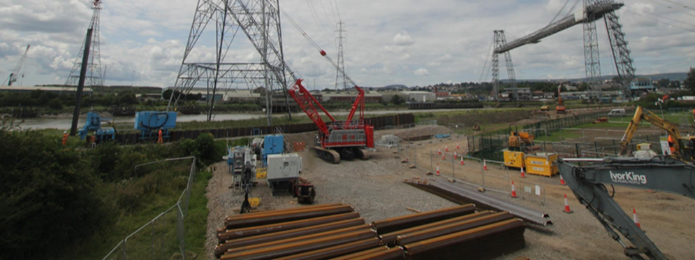
Case study – Flood alleviation scheme at Stephenson Street, Liswerry, Newport
Stephenson Street is our largest and most complex flood scheme ever. Taking account of future climate change, more than 1,100 homes and 1,000 non-residential properties will be better protected from tidal flooding across Liswerry now the scheme is complete. Approximately 2km of raised defences (flood bund, sheet pile and reinforced concrete walls) have been constructed within budget and programme in the complex urban location, next to nationally significant sensitive saltmarsh, businesses and utilities. Our collaborative and innovative approach has enabled delivery of low-carbon, sustainable solutions as well as the early identification and utilisation of a local supply chain. The design has been constructed in an efficient and environmentally sensitive manner, and safeguards the wellbeing of future generations. The scheme also provides enhancements to the nearby section of the iconic Wales Coast Path and community green spaces. The scheme also supports nature by planting trees and wildflowers and creating urban forest areas and reedbed habitat.
Figure 2: Photo showing the construction of the Stephenson Street flood defence
Asset management
We undertake routine inspection and maintenance programmes to ensure our flood risk assets are fit for purpose. We maintain over 3,900 flood risk management assets which includes approximately 455km length of raised defences throughout Wales.
At the end of the financial year 2024/25, 14,289 routine asset inspections have been completed on assets. In addition, 887 post incident and ad hoc inspections have been undertaken following storm events. We prioritise asset inspections on a risk basis, but there are improvements to make to ensure that all inspections are carried out and are on time. We have trained more asset inspectors to improve on this in 2025/26.
At year end, our inspections found that 97.23% of our flood assets in high flood risk systems were found to be at or above their required condition to effectively perform their function. This falls just short of our corporate performance measure target of 98%. This is a rolling target, reflecting that some assets will inevitably not be at target condition. Assets not at target condition are scheduled for repair or improvement work.
In 2024/25, we undertook 20,587 individual actions as part of our Routine Maintenance programme. This meant that defended areas benefitting 79,633 properties across Wales received at least 60% of the identified maintenance needs for these areas. Whilst this work is constrained by our available resources and funding, the prioritisation of these works continue to be improved by the Risk Based Revenue Allocation Model project summarised below.
Alongside our routine maintenance programme, we have a number of projects ongoing to help improve asset management within NRW and these are described below.
Flood Risk Asset Management System
This year as part of our wider Flood Risk Asset Management System (FRAMS) project to improve the management of our flood risk assets, we have delivered the Strategic Asset Management Plan (SAMP). The SAMP will help us to take an integrated approach to the management of FRM assets and has allowed us to start on the next step of creating Asset Management Plans and implementing them. FRAMS will play a key part in improving the efficiency of how we manage our FRM assets. This will bring multiple benefits to the Welsh Public and add future proofing especially in times of climate change).
Risk based revenue allocation model (RBRAM)
This year we continued to embed and improve the Risk Based Revenue Allocation Model (RBRAM), which utilises our asset management database (AMX). The aim of this work is to prioritise routine asset maintenance and allocate funding in a more efficient and effective, risk-based, way. It considers factors including the level of risk, the criticality of undertaking certain actions, the economics of each action and whether there are other drivers for our work, including legal commitments. Throughout this year we have continued to improve the guidance, standards and specifications in relation to this work. As we capture more data from the delivery of our maintenance work we are continuously improving the evidence and assumptions made by the model. This work will enable us to ensure our maintenance is prioritised on a risk basis, ensuring we deliver the best value for money through our works whilst also ensuring that maintenance obligations are met.
NRW FRM Statutory Permissive Powers
We have produced a position statement that explains our remit in relation to flood and coastal erosion risk management, and the permissive powers we have under the Water Resources Act 1991. This helps to explain how we use these powers to apply a risk-based approach to flood risk management to reduce the risk of flooding to people and property. We hope that this Position Statement will help our partners and stakeholders to also understand our legal remit and powers and how we exercise them when making decisions.
Case study - what we do - Lower Dee Integrated Workforce Team
In NRW, we have 9 Integrated Workforce teams across Wales that deliver the operational activities involved in maintaining our flood defence assets and ensuring that the protection they provide to communities is sustained. This includes delivering our planned Routine Maintenance Programme, as well as dealing with reactive repair works and undertaking work supporting our Capital Programme. These teams also play a vital role in our incident response capacity, ensuring that our structures are able to perform effectively and where relevant, that they are deployed in the right places and in a timely manner. As these teams undertake flood risk management works, they also aim to deliver environmental enhancements and minimise the impacts of our works on the environment, helping NRW’s response to the Nature Emergency.
The Lower Dee is one of our integrated workforce teams and has 13 team members that cover the geographic area of the Upper and Lower Dee from Bala to the Dee Estuary. The members of the Lower Dee integrated workforce team are highly skilled and trained individuals that have experience in multiple disciplines such as chainsaws, confined spaces, heavy goods vehicles, specialist excavators, chemical spraying and lifting operations. They also possess invaluable local knowledge of their area which is crucial whilst responding during storms.
Throughout 2024/25, the team undertook the following tasks:
- Small capital schemes (up to £25k in value) that have delivered flood risk improvements to Bretton Drain, Wepre Flood Alleviation Scheme (FAS), Worthenbury FAS, and Bangor on Dee FAS.
- Undertaking over 5,600 routine maintenance activities on flood defences such as mechanical weed cutting and grass cutting.
- Providing response to over 60 incident response alarms which included clearing trash screens, setting up and operating mobile pumps, and erecting flood barriers systems. These response alarms were mostly at night and in difficult working conditions.
Reservoirs safety
There are over 400 large raised reservoirs registered in Wales with a capacity of 10,000 cubic metres of water, or more, held above natural ground level and stored behind a dam, embankment or other structure. The failure of these structures can cause flooding, damage, pollution, loss of utility and can pose a risk to life.
We are the enforcement authority for the safety of large raised reservoir in Wales. We have a duty to ensure that those who own, manage or operate them observe and comply with the Reservoirs Act 1975 to protect people and property from an uncontrolled release of water. This law sets the minimum standards to ensure the safety of reservoirs, predominantly to ensure reservoir undertakers appoint and act on the advice of specialist qualified civil engineers.
We also manage a portfolio of reservoirs for flood risk and conservation purposes and manage reservoirs in the Welsh Government Woodland Estate on behalf of the Welsh Ministers. Our key activities in these two roles are described below.
Our regulatory role
The register of large raised reservoirs
There are 405 large raised reservoirs recorded on the public register. The number and status of these reservoirs over the last five years are shown the table below.
Table 7: The number and status of large raised reservoirs registered as recorded on 31 March over a five-year period.
| Status | 2021 | 2022 | 2023 | 2024 | 2025 |
|---|---|---|---|---|---|
| Under construction | 8 | 12 | 8 | 8 | 7 |
| In operation | 363 | 384 | 388 | 393 | 397 |
| Abandoned | 0 | 0 | 1 | 1 | 1 |
| Total | 371 | 396 | 397 | 402 | 405 |
The responsibility for reservoir safety and for legal compliance falls to the undertakers of which in Wales:
- 35% are statutory water companies
- 26% are private landowners
- 21% are managed by publicly funded bodies:
- local authorities (10%)
- Natural Resources Wales (9%)
- national park authorities & Cadw (2%)
- 18% are managed by other organisations.
The undertakers may use reservoirs for many different uses as well as traditional water supply, including hydro-electric power generation, natural and heritage conservation, recreation, river regulation, flood control and general amenity.
Figure 3: The number of compliant and non-compliant reservoirs in each principal undertaker group recorded at the close of the period on 31 March 2025.
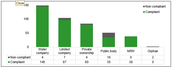
The reduction in performance around the need for inspection has occurred because of the timing of inspections at orphan reservoirs, where no owner exists. We have recorded this as non-compliance but have taken steps to ensure the required inspections are completed.
Compliance with the completion of statutory safety measures is poor. Safety measures can include the requirement for investigations or surveys, and failure to comply does not subsequently equate to a reservoir being unsafe. They are important however and this measure indicates that the reservoir does not meet the standard expected.
We take advice from engineers on the seriousness of the failure and during the period we have used enforcement powers to require completion of safety works but we have not considered it necessary to take emergency action to avert an incident.
Reform programme
In autumn 2024, Welsh Government confirmed its commitment to addressing the recommendations made by Professor Balmforth in his report into how reservoir safety is regulated (Reservoir review: part B (2020) - GOV.UK (www.gov.uk)). There are 15 recommendations and 52 sub-recommendations to be addressed.
We have actively engaged in this programme to support Welsh Government, the Department for Environment, Food and Rural Affairs (DEFRA) and the Environment Agency. We continue to develop these proposals to enable public consultation in due course. The reform programme will help us move from compliance to safety by focussing regulatory effort on those reservoirs that hold the highest risk.
Post incident reporting
During the report period we recorded five incidents at large raised reservoirs. The incidents required some precautionary measures to be taken. These incidents were responded to by the undertakers, and none required us to step in using emergency powers.
We are working with the Institution of Civil Engineers and the Environment Agency to produce an online database of reservoir incidents. The purpose of this is to provide better information to reservoir owners and engineers on the sorts of incidents that occur, the shortcomings found, and the lessons learnt from them. This is due to be published shortly.
Reservoirs managed by NRW
We manage 38 reservoirs in Wales. These reservoirs are inspected and supervised by qualified civil engineers, and we maintain a programme of works to address the recommendations they may make. The table below shows the purpose and risk designation of reservoirs managed by NRW.
Table 8: The purpose and designation of reservoirs managed by NRW.
| Purpose | High risk | Not high risk | Undetermined | Total |
|---|---|---|---|---|
| Flood risk management | 11 | 2 | 0 | 13 |
| Conservation (National Nature Reserves) | 3 | 5 | 0 | 8 |
| Welsh Government Woodland Estate | 12 | 4 | 1 | 17 |
| Total | 26 | 11 | 1 | 38 |
For more information, our biennial reports are available on our website: Natural Resources Wales / Biennial reports on reservoir safety.
Advising planners, permitting and enforcement
This work area relates to all discretionary and statutory advice in regard to flood risk and our role as a consultee within the planning process. The aim is to provide effective advice to influence and control development in flood risk areas, preventing more people and properties becoming exposed to increased flood risk. It also includes our permitting regimes. Combined, these roles seek to control development in flood risk areas and flood risk activities in or around main rivers. We also undertake enforcement where flood risk activities may cause or exacerbate flood risk or result in environmental harm.
Updating TAN15
The Welsh Government published a revised planning policy TAN15: Development, Flooding and Coastal Erosion (TAN15) on 31st March 2025, at the very end of the year covered by this report. This has replaced the 2004 version of TAN15 and TAN14 (1998) on coastal erosion risks. The Flood Map for Planning (FMfP), first published in September 2021 has now come into effect and replaces the Development Advice Map. The FMfP represents the best available information we hold on flood risk now and in the future, and can also be used to identify coastal erosion impacts.
We provided technical information and advice to WG during the course of the year to aid them in their decision making for the new TAN. We also ensured that the new Flood Map for Planning (which NRW maintains and houses on our website) was ready, as required by WG, to sit alongside the new TAN15.
We will apply the revised TAN15, alongside the FMfP in our technical advice to planning consultations on flood risk from rivers and the sea, using it as the framework to establish whether the risks can be appropriately managed.
There will be a period of adjustment while we understand the changes in planning policy. However, our advice to Local Planning Authorities will continue to be based on the principles set out within the revised TAN15.
Development planning advice
As of 31 March 2025, we are a statutory consultee on flood risk for all development proposals in Flood Zones 2, 3 or a TAN15 Defended Zone of the Flood Map for Planning (FMfP) for both rivers and the sea. The FMfP has replaced the Development Advice Map and supports the revised national Planning Policy TAN15. It is used primarily as a screening tool to understand where further assessment of flooding and coastal erosion may be needed and indicates how climate change may affect flood extents over the next century. A full description of the FMfP can be found on our website.
Over the past year, our technical flood risk advice has helped to prevent inappropriate development being approved in locations where the risk of flooding would be difficult to manage. Where development has been permitted despite the flood risks, we have provided advice on the risks and consequences so that flood resistance and resilience measures can be considered and incorporated within development to help reduce the risk both now and in the future.
During 2024/25, our technical advice was based on the 2004 version of TAN15 and the associated Development Advice Map. We received and responded to around 2100 planning consultations where flood risk was identified by the Local Planning Authority as a potential constraint. We provided a substantive planning response to these statutory consultations, providing technical advice on the flood risks and consequences. Of the consultations received, over 1000 proposals were in areas described as Zone C2 on the Development Advice Map.
Flood Map for Planning - further enhancements
We continue to update the Flood Map for Planning on a 6 monthly cycle, in May and November. We use updated local flood models, evidence provided by local authorities on flood risk from ordinary watercourses and surface water and data from successful flood map challenges to update. Work to include wave overtopping data along some stretches of the Welsh coastline into the underlying flood extents is continuing and will be progressed over the next few years.
Regulating flood risk activities
We regulate activities carried out on or near a main river, on or near a flood defence structure, including a sea defence, or within a flood plain, under the Environmental Permitting Regulations 2016. We do this by issuing a Flood Risk Activity Permit (FRAP) to ensure the activity does not cause any increase in flood risk, adversely impact land drainage in the area, or cause environmental damage to the local environment, fisheries, or wildlife. Some permits we issue cover multiple flood risk activities under the same permit where they are undertaken within the same location and have the same site characteristics. This is subject to certain conditions and constraints. Some flood risk activities can be carried out without a permit but may need to register with us as ‘exempt’ from the need for a bespoke permit.
Over the 2024/25 financial year, we issued 204 Flood Risk Activity Permits across Wales and 46 exemptions were registered.
Enforcement activity
We undertake flood risk enforcement under the Environmental Permitting (England and Wales) Regulations 2016. This work is important to ensure the effective management of flood risk and to support protection of the environment. If our regulatory advice is not sought, or is ignored, when undertaking works on or near main rivers or flood defences the consequences could be serious. In addition to managing flood risk, our enforcement activity ensures we can maintain access to flood/sea defence infrastructure and allow us to undertake important maintenance and improvement works. We can also use enforcement action to rectify unlawful and damaging or potentially damaging work, which may have been carried out in contravention to conditions set out in a flood risk activity permit, or without a required flood risk activity permit. Examples include damage to flood defences and control structures, removing obstructions that impact flow within rivers, potentially increasing flood risks, and works that have caused harm to the environment.
During 2024/25 we registered 70 cases across Wales where enforcement action for unpermitted flood risk activities or non-compliance with a flood risk activity permit was required. We completed enforcement action on 56 cases during this period.
Case study – unpermitted works, Efailnewydd, Pwllheli
Our officers responded to a report of unpermitted works following the construction of a flood bund within the floodplain of the Rhyd Hir river near Efailnewydd, Pwllheli. They found work had been carried out to erect a 1m high earth flood bund that ran approximately 150m along the floodplain to reduce bank erosion. The landowners admitted to carrying out the works and said that they were not aware of the need for a Flood Risk Activity Permit. They agreed to cooperate and carry out any necessary changes.
Our officers issued a Remediation Notice to remove material from the bund down to field level at 20m intervals for a length of 3m along the length of the bund. This was to ensure floodwaters were not restricted during periods of tide-locking at the tidal defence downstream of the site in Pwllheli as this would increase the flood risk to other properties. The Notice was complied with and the case was closed with a Warning Letter.
Figure 4: Photo of unpermitted earth bund along the river Rhyd Hir
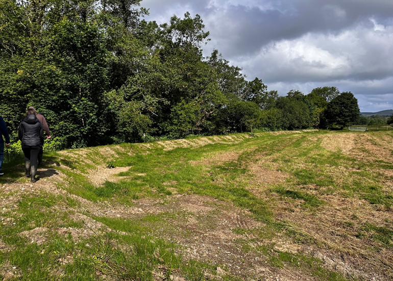
Figure 5: Photo of remediation works where the earth bund has been breached at 3m lengths with 20m intervals
Delivering hydrometry, telemetry and hydrology services
This work area delivers our hydrometry, telemetry and hydrology services which collect, analyse and report data which underpins a range of flood and water management services across NRW. This includes flood risk modelling and mapping, flood risk scheme appraisal and design (standards of protection), reservoir safety, flood forecasting and warning, river regulation and post flood assessments (in terms of the amounts of rainfall, river levels recorded and their severity e.g. historic ranking or return period).
As well as gathering, processing, and archiving this data for NRW, this work area also reports and shares the data with internal and external customers through specific data requests, data transfers and provision of digital services on our website including our live River Levels, Rainfall and Sea Data service.
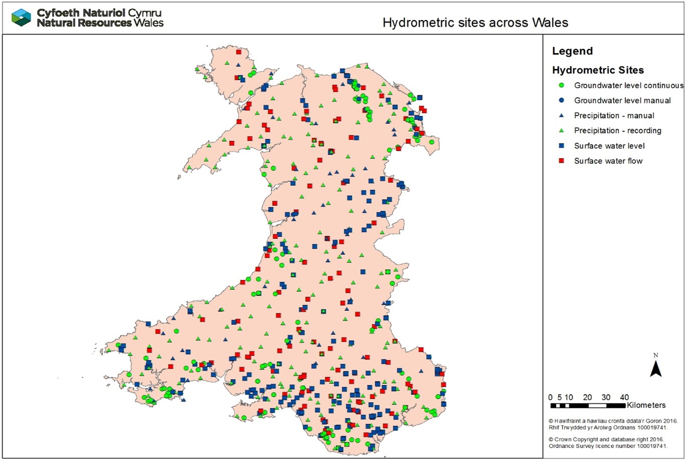
Hydrometric network
The hydrometric network across Wales comprises 253 rain gauge stations, 333 river level or flow monitoring stations and 135 groundwater level monitoring stations. Figure X is a map showing the locations of all monitoring stations across our Welsh Hydrometry and Telemetry (H&T) network. There have been minimal changes to the hydrometric network in recent years as the result of a resource pressures on H&T in Wales. Any additions to the network have been limited to previously agreed installations to support statutory monitoring requirements.
Figure 6: Hydrometric sites across Wales
Hydrometric network review project
This year, we have completed a project to capture detailed hydrometric network and station data to understand the resilience of our monitoring stations. This significant review has enabled us to make recommendations and decisions to ensure that the network can continue to deliver the required service. Further work is ongoing to prioritise the recommendations to improve the resilience of critical monitoring stations in the network.
Work also started this year to consider the hydrology and telemetry service costs and staffing requirements to ensure resources are distributed effectively. This work will continue into 2025/26.
Telemetry replacement project
We have continued to make significant progress with our £5m investment project to deliver a new Telemetry System. This project is critical to enable NRW to continue to gather and share near real time river, rainfall and operational plant information which underpins our response to flooding incidents and water management, including drought. It will replace ageing systems and infrastructure which are reaching the end of operation. Our new telemetry data portal is live and all external customers have migrated over to it and 565 out of 611 telemetry stations have been transferred to the new system. Work on the main system build continues into 2025/26.
UK Flood Hydrology Roadmap
We have continued to work closely with our partners in England, Scotland and Northern Ireland to take forward implementation of the Flood Hydrology Roadmap that was published in March 2022. This year we have worked collaboratively with our partners across the UK to develop a framework to benchmark hydrological models. We have been involved with a Research and Development project on extreme rainfall which will contribute directly towards the delivery of certain roadmap actions and we co-hosted an interactive workshop to explore the barriers and opportunities for the translation of flood hydrology science into practice. We also facilitated a reflective exercise with the Governance Board and Scientific and Technical Advisory Group members to evaluate both the progress being made and challenges with delivering Roadmap actions. An action plan has been developed to address these challenges.
Flood forecasting and issuing warnings
This work area delivers our flood forecasting and flood warning services to the public and professional partners. Its purpose is to provide effective warnings and information to people at risk of flooding enabling them to take direct action to protect life and property in the build up to a flood event.
It includes the detection and forecasting of flooding in real time in the lead up to and during flood incidents, and the issuing of flood warnings to those directly at risk. It also includes the provision of information on the latest situation and warnings in force via our website, Floodline and our live data portal.
Our teams also ensure that data, systems, operational procedures, training of duty staff and management of duty rotas are all in place - and tested and improved – such that they are ready and fully effective in flood events. The services are delivered by a number of specialist duty officer rotas using staff from our teams. Our duty officers are on standby duty 24/7 365 days per year ready to respond to potential and actual flooding at any time of day or night.
Flood Forecasting and Warning over the 2024/25 financial year
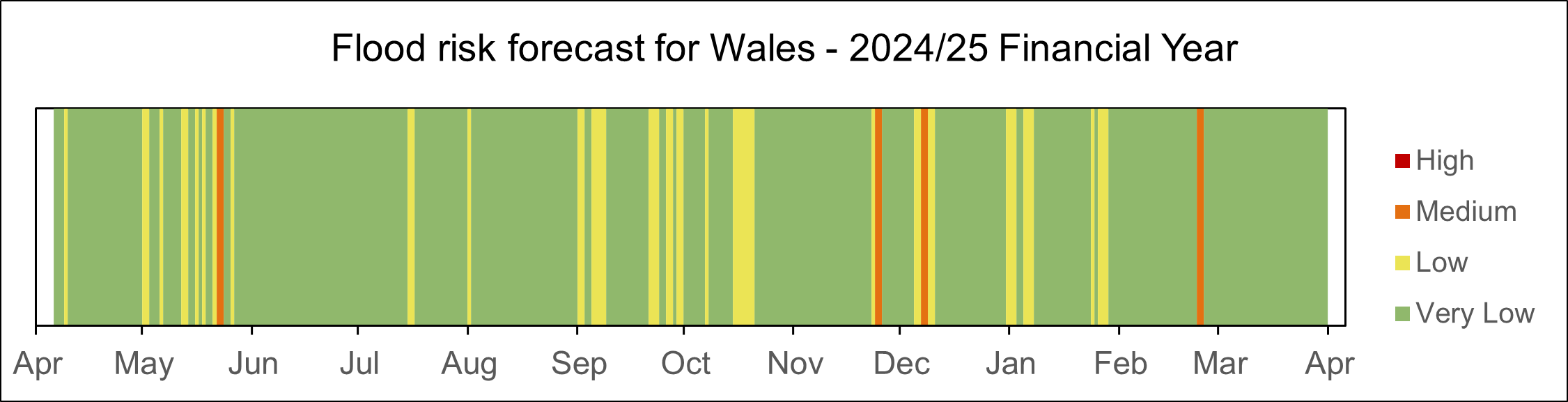
Elevated flood risk is highlighted through the Flood Guidance Statement which provides a daily flood risk forecast for 5 days to Government and professional partners to assist with strategic, tactical, and operational planning decisions around developing flood risk. The information is also shared with the public through our website. From April 2024 to March 2025, there were 102 days of elevated flood risk (minor forecast impacts and above) and within those, 40 days of heightened flood risk (significant forecast impacts and above). Section 1 of this report describes the main flood events during the year that led to elevated flood risk and associated impacts.
Figure 7: Barcode showing the flood risk forecast for Wales for the 2024/25 financial year. There is a line for every day of the year, shaded according to the predicted flood risk.
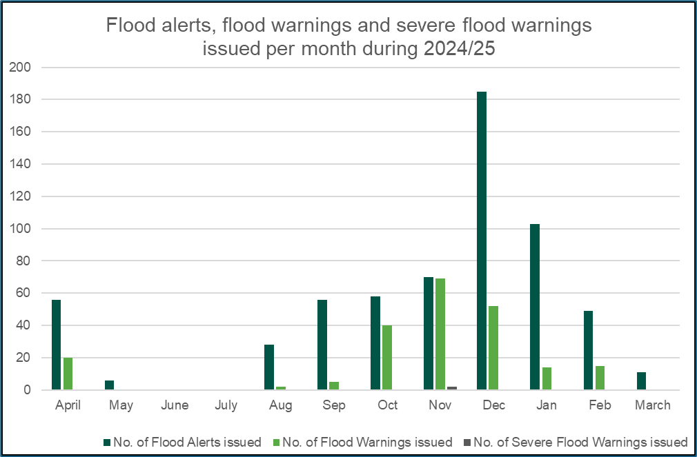
Across Wales, there are over 48,000 properties fully registered to receive our flood warnings. In total, we issued 622 flood alerts, 217 flood warnings and two severe flood warnings during 2024/25 in response to the risk of flooding. There were 1,163 calls made to Floodline agents and 1,392,763 visits to our flood warnings and alerts webpage. November was the month with the most visits to our website with nearly 400,000 total visits resulting from Storm Bert.
Figure 8: Number of flood warnings and alerts issued during 2024/25
Improvements to the flood forecasting service
We have worked this year to develop new and improve existing flood forecasting models for both river and the sea flood risk areas.
We have developed new river flood forecasting models for locations on the Upper Wye, Taff and Cadoxton which will be going live in 2025/26. In addition, we have continued to improve our existing models and have made improvements to our forecasting models for the rivers Conwy, Severn, Vyrnwy, Cleddau and Usk.
We have also strengthened our coastal flood warning service by rolling out the Wales Coastal Model to approximately 40 locations in South West Wales. This enables our duty officers to see forecast conditions and threshold exceedances for up to 5 days ahead.
In total across Wales, we provide flood forecasts for 89 sea flooding locations and 112 river flooding locations.
Flood Forecasting systems ICT update
We have undertaken a large piece of work to complete a major system upgrade for the Flood Early Warning System (FEWS) and associated modelling software. This system is used to run all of our flood forecasting models which produce flood forecasts (for fluvial and coastal flooding) for 5 days ahead. This system upgrade improves functionality and ensures the resilience of the system.
Flood forecasting rota resilience
We have completed the training of new duty officers to strengthens the Monitoring & Forecasting Duty Officer (MFDO) rota. The new duty officers have gone through an extensive period of training and are now operational. This brings the rota up to the minimum number of required duty officers and ensures resilience to manage ongoing events.
Developing the ‘going severe’ protocol
The Flood Guidance Statement is a 5-day risk based map for England and Wales that is available to key partners and the public. It shows the forecast level of flood risk for the coming 5 days for surface water, river, groundwater and sea flooding through appropriate shading on the map. This ranges from green for low risk to red for severe impacts. Our duty officers check the forecast level of risk along with the predicted impact for Wales to advise on the accuracy of the information shown. To support our Duty Officers with this task, we have completed work to develop a process to support decision making on when to go upgrade predicted risk for Wales, including severe impacts on the Flood Guidance Statement.
Flood Warning System Renewal Project
Our new Flood Warning Information Services for Wales (FWISfW) went live on 17 July 2024. Issuing flood warnings are critical for us to fulfil our statutory obligation to warn others of the location, timing, and magnitude of flooding from rivers and the sea in Wales. It has since been used to successfully issue Flood Alerts and Flood Warnings for river and coastal flooding, including during Storm Bert and the other winter storms of 2024/25
This was a significant project which has enabled us to deliver new multi-media Flood Warning Information Services for Wales. This project now allows us to provide our own independent flood warning service for the people of Wales. For continued consistency for our customers, the flood warning codes, thresholds we issue warnings at and properties we send warnings to did not change on go live.
The new Flood Warning Information Services for Wales allows for a more efficient process for issuing Flood Alert and Warning messages by our duty officers, so it is reduces their workload during flooding incidents and enables faster issuing of messages to those at risk. It also enables better clarity and consistency in our Flood Alert and Warning messages so that they provide more direct advice, related to potential or expected impacts.
You can sign up to our new Flood Warning Information Service here: Natural Resources Wales / Sign up to receive flood warnings.
Community engagement and resilience
This work area delivers our community engagement and resilience services to communities at risk of flooding across Wales. It includes provision of information and advice to those at risk of flooding on the practical steps they can take to be better prepared before, during and after flooding. We provide this advice digitally via our website and directly with communities, including providing flood plan templates for them to use and facilitating volunteer network events to share knowledge, experiences, and best practice. Our enabling role is important for partners to be able to do their own local engagement with communities using our digital and print resources as well as come together with community leads.
Social media messaging
In 2024 we reviewed and updated all of our flood social media assets, and created new materials to communicate the risk of surface water flooding, which can be difficult to predict due to intensity and location/duration. We shared these messages and graphics with Welsh Government’s Local Resilience Forum Communications Group, so that they can be used by partners and messaging is consistent.
Community Flood Plans
Community flood plans are volunteer and community led. As of April 2024, we help maintain 76 community flood plans in place across Wales to ensure they are fit for purpose and service the communities that own and use them. These plans are those reported to NRW either by public or partners and for which we have up to date contacts for; there may be others we are not aware of. NRW have an supporting role in these plans along with other organisations offering advice and guidance. During 2025/26, we will carry out an audit of Community Flood Plans to check which plans are still active. This enables us to focus on communities that are in a position to develop and maintain a community flood plan. It will also inform us of the locations of those communities so we can offer them support, signpost them to other volunteers for networking and advice (and keep them updated of news and events relevant to them).
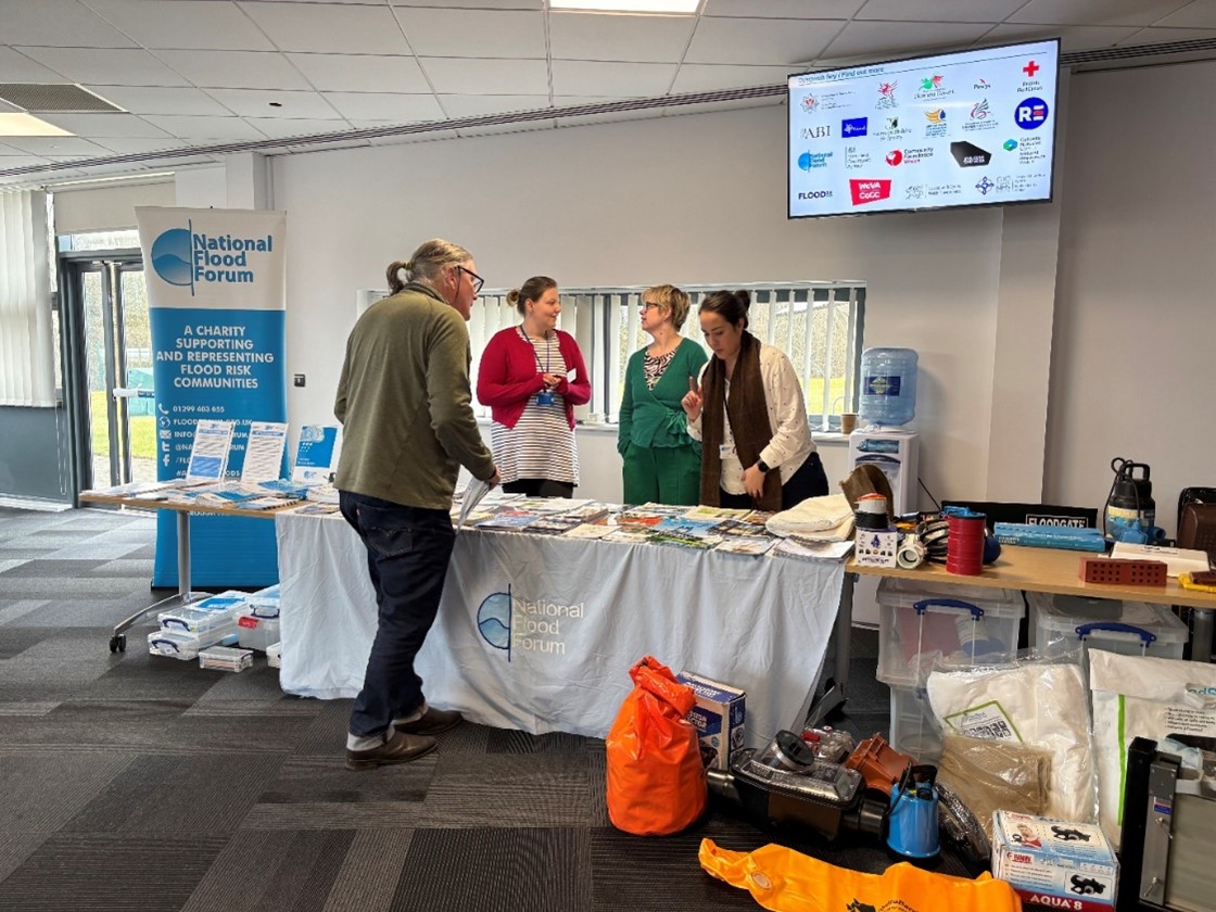
Flood Volunteer Network events
We held two Community Flood Volunteer network events, one in Merthyr Tydfil and one in Aberystwyth, which provided an opportunity to connect with the public and partners face to face. Based on feedback from the previous year’s events, we concentrated these events on Flood Recovery. There were short presentations from professional partners and NRW explaining their roles and support offered in the flood recovery process. In total, 12 communities were represented by 24 community members. 43 professional partners attended and contributed to the planning and discussions on the day.
Figure 9: Photo from the flood volunteer engagement event at Merthyr Tydfil, 6 March 2025
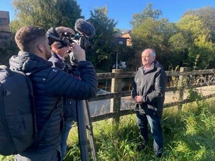
Flood campaign week #BeFloodReady
In October 2025, we launched our #BeFloodReady awareness campaign (7-11 October). The campaign focussed on winter preparedness, providing essential advice about what people should do if they live in an area at risk of flooding, and encouraging them to sign up to the new Flood Warning Information Service.
We held media interviews and delivered messages though social media. Throughout the week, we delivered important messages around the three steps we need people to take to prepare for flooding - check risk by postcode, sign up for warnings, and know what to do to prepare for flooding. We secured coverage on BBC Breakfast news bulletins, ITV Wales, S4C, radio bulletins) lunchtime and evening news and across print and online. A key part of our campaign was to promote the fact that the Flood Warning Information Service was available in Welsh. We worked alongside the Welsh Language Commissioner to share this message, supported by social media content.
Figure 10: NRW National Flood Risk Services Manager providing a media interview during #BeFloodReady campaign week
BBC Wales and S4C
During our #BeFloodReady awareness social media campaign (7-11 October 2024), we spent time at BBC Wales HQ in Cardiff’s Central Square, briefing weather forecasters and journalists from BBC and S4C. Our objective was to help them report flood risk in the right way and point people to the services on our website when flooding is forecast. This provided the opportunity for the BBC/S4C to better understand what we do, how we work with partners and how they can better share advice in relation to flood risk in their broadcasts.
Sustainable flood risk management in the face of coastal change
Coastal communities in Wales face challenges from the existing risk of flooding from the sea, as well as ongoing physical changes and the pressures that climate change is likely to place on them in the future. We play an important role in managing coastal flood risk assets and also working with partners to plan for future changes and the requirements for adaptation over the long term. Within this context, we continue to deliver our responsibilities in relation to Shoreline Management Plans and we aim to align our works to the policies contained within these Plans.
Coastal adaption planning
We deliver the National Habitat Creation Programme (NHCP) on behalf of Welsh Government. This was created to meet statutory requirements to provide compensatory habitat offset for coastal plans and projects, where impact on habitats cannot be avoided, which are delivered by Risk Management Authorities across Wales. This helps support Wales to have a sustainable coastline that is resilient and adapted to climate change. During 2024/25, we continued to investigate and develop opportunities for the delivery of compensatory habitat in the Dyfi Estuary, Porthmadog, Pwllheli, Mwche and Laugharne.
The focus and approach to delivering the strategic requirements of the NHCP has evolved to be included as part of the wider Coastal Adaptation Programme (CAP) in response to changing FRM priorities, UK legislation, and Welsh Government policy on compensatory measures. We also work collaboratively with Local Authorities and engage with public and stakeholders and integrate, where appropriate, nature-based solutions into the delivery of coastal defence schemes.
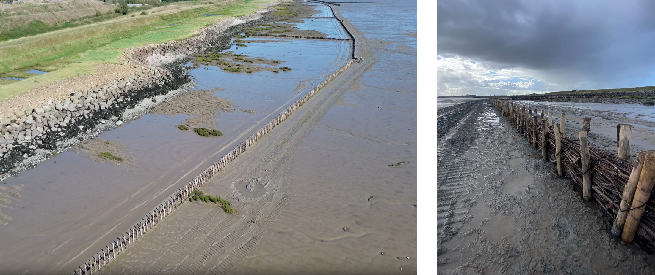
Case study – Rhymney Great Wharf Polders
This year, work to restore the saltmarsh habitat along the Severn Estuary near the Rhymney Great Wharf in south Wales, has been completed. The project will help to increase biodiversity and resilience in the Estuary as well as reducing flood risk in the area.
Delivered as part of the Welsh Government-funded Nature Networks programme, the restoration has included the renewal and extension of over 2km of sedimentation polders along the foreshore. The structures, which are made of chestnut posts and brushwood bundles, help encourage the establishment of saltmarsh habitat, by slowing the movement of the tide as it recedes, allowing sediment to be deposited within the polder fields.
Over time, mud and sand builds up and turns into saltmarsh. This will help restore the important habitat of the Severn Estuary, supporting local wildlife and helping to trap carbon. The Estuary supports some of the most important and protected habitats in the UK, and is designated as a Special Area of Conservation (SAC). It hosts a significant number of waterfowl and aquatic invertebrate as well as providing a valuable corridor for migratory fish.
This nature based solution will also help to enhance the existing flood defences and reduce future flood risk by reducing pressure from erosion.
Figure 11: Rhymney Great Wharf Polders
Strategic planning
We lead on strategic flood policy matters, develop long term plans and ensure FRM delivers programmes of work in effective and efficient ways.
Skills and capacity
We recognise the need for more focus to be placed on skills and capacity building within FRM and we are working to ensure that we support the development of our staff and have the right skills so we can meaningfully tackle our future challenges.
During 2024/25, we continued to invest in FRM skills and development. The main highlights were:
- We delivered a range of FRM training courses including FRM related conferences, post graduate studies and technical courses including Construction (Design and Management) (CDM) Regs, asset inspection accreditation and AutoCAD.
- We held two further FRM induction courses following the successful pilot held in July 2023. The aim of the induction course is to provide new FRM practitioners a foundation in understanding how flood risk is managed in Wales and included presentations on areas such as asset management and flood risk management law. Over 75 new or relatively new starters, attended the three courses in total with attendees from across all Risk Management Authorities (RMAs). The course content was delivered by specialists from within the RMA group who kindly gave up their time to support the events. As well as providing key learning, the face-to-face courses have provided an excellent opportunity to meet colleagues from neighbouring flood risk authorities and to develop working relationships into the future.
- We have developed a programme of site visits to locations with an FRM interest such as flood alleviation schemes and coastal adaptation sites. The first visit of the programme was to the Gwydir Reservoirs refurbishment project in North Wales that was attended by both NRW staff and those from other RMAs. These visits will provide an opportunity for Continued Professional Development and allow FRM professionals to meet in person.
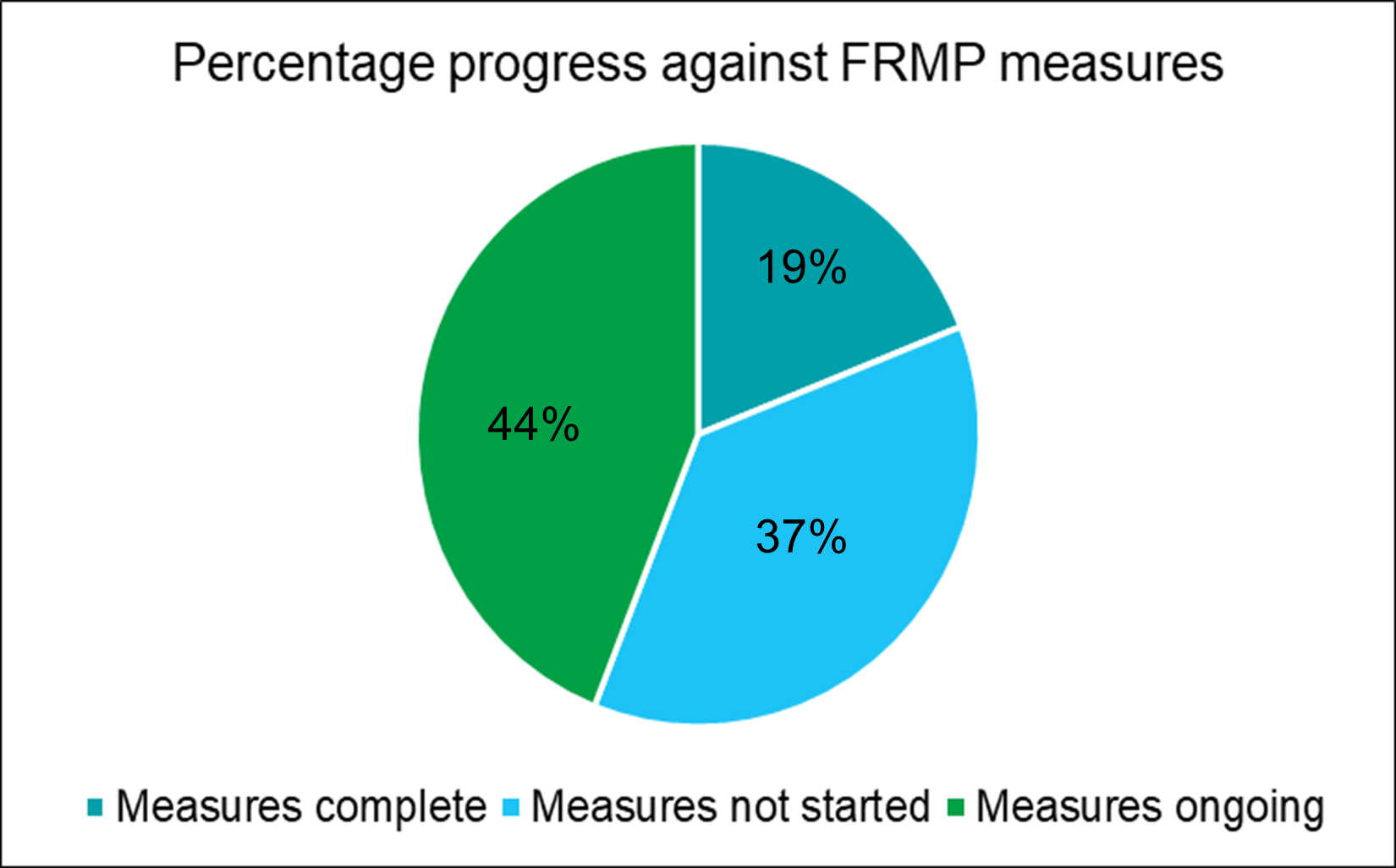
Flood Risk Management Plans (FRMP)
We published our updated Flood Risk Management Plan in November 2023. The plan covers all of Wales and sets out the priorities for managing flood risk for the next six years for the areas of flooding for which we have lead responsibilities: flooding from rivers, reservoirs and the sea. The Place focused sections of the Flood Risk Management Plan contain planned measures and actions with the overall objective of reducing the risk to people and communities from flooding. We have made good progress delivering these measures. At the time of writing this report, 57 measures from the plan are complete, 130 measures are underway and 112 measures are not yet started. These figures include over 40 measures that have been added to our work plan since the start of the FRMP which shows how we add new measures and actions to our work plans once other measures are complete.
The pie chart below illustrates the percentage progress against our FRMP measures.
Figure 12: Pie chart showing FRMP measures progress
The measures that have been completed since the start of the FRMP include:
- Improvements to our existing hydraulic models at Swansea, Aberdulais, Bedwas, LLanbradach, Machen, Glyntaff, Hirwaun, Mountain Ash, Nant Garw, Taffs Well, Treforest, Bala, Llanuwchllyn, Pwllheli, Mold, Queensferry-Sandycroft-Manor Lane, Rhydymwyn, Guilsfield, Llandinam and Meifod.
- Completing new hydraulic models at Ynysybwl, Abergwyngregyn and Knighton.
- Improvements to our existing Flood Warning service at Ammanford, Bedwas, Llanbradach, Machen, Ystrad Mynach, Aberdare, Dinas Powis, Glyntaff, Hirwaun, Mountain Ash, Nant Garw, Rhydyfelin, Taffs Well, Treforest, Beddgelert, Dwyran – Braint, Llanfair Talhaiarn and Mold.
- The design and construction of improvements to our flood attenuation reservoir in Cowbridge.
- Completing initial assessment and feasibility work to consider how we might reduce flood risk in Aberdare, Glyntaff, Hirwaun, Mountain Ash, Nant Garw, Rhydyfelin, Taffs Well, Treforest, Amlwch, Dwyran and Clwyd - Ffynnon y Ddol.
- Developing a scheme appraisal for a flood alleviation scheme in Llangefni.
- Carrying out structural assessments on existing structures in Garden City and Deeside Ind Est and Rhyl to ensure they are fit for purpose.
FRM Research and Development
We have a strategic Research and Development (R&D) programme aimed at delivering key evidence to inform and improve our operational and policy needs across FRM. To help meet our research and evidence needs, we work in collaboration with the Welsh Government, Environment Agency and Defra on the joint Flood and Coastal Erosion Risk Management (FCERM) Research and Development programme. The programme aims to serve the needs of all flood and coastal operating authorities in Wales and England. Over the last year, the Joint Flood and Coastal Erosion Risk Management R&D Programme has published several key projects in which NRW has been involved including the Example approaches to transferring or decommissioning flood and coastal erosion risk management assets & Growing evidence of the benefits of natural flood management . The full list of projects can be found on the FCERM research and development projects site.
The wider R&D programme consists of 40 projects split into 3 theme areas: 1) Policy, Strategy and Investment, 2) Asset Management and 3) Incident Management and Modelling. Our staff are engaged directly with 20 of these projects either as a corresponding member or actively involved at a project board level.
Over the last year, we have been using the eight areas of research interest (ARIs) that were identified through the joint research plan as part of the Joint R&D Programme to help identify a range (130) of evidence needs from our staff. More details on ARIs can be found here.
Flood Centre for Doctoral Training (Flood CDT)
The Natural Environment Research Council (NERC) have awarded £6.5m of funding to create a Flood Centre for Doctoral Training (Flood CDT). This program is a significant initiative with the main goal to train the next generation of researchers with the skills and knowledge needed to address the complex challenges of flooding. We have joined a Flood CDT steering group to support this initiative and help to ensure that the research projects that follow are supported to provide “real world” benefits. In supporting the initiative, we have provided PhD students with places on the FRM induction course to help develop their understanding of how flood risk is managed and to develop links with specialists in their specific areas of research.
Nature based solutions
Nature-based solutions (NBS) refers to the use of natural features and processes to tackle socio-environmental issues. Natural flood management (NFM) is considered to be a nature based solution to help address flooding by using or restoring natural processes to reduce the risk of flooding and coastal erosion. NFM can also provide many wider benefits including biodiversity improvement, increasing ecosystem resilience, improving water quality and storing carbon.
A key priority of the Welsh Government National Strategy for Flood and Coastal Erosion Risk Management (FCERM) in Wales is to deliver more natural interventions and catchment based approaches to reduce flood risk. Flood risk management authorities in Wales are required to consider the use of NFM when developing options for new flood schemes and maintenance activities. We aim to integrate NBS within flood and coastal risk management activities where feasible and appropriate.
Using the latest evidence, we have developed supplementary guidance for the initial assessment of our flood and coastal erosion risk projects. This guidance will be tested, and refined over coming years (as our knowledge and understanding increases).
Developing our approach to NFM
As an organisation we want to lead by example, delivering our corporate objectives to protect and enhance nature, respond to the climate emergency, and minimise pollution. The implementation of NFM measures has the potential to deliver against these objectives and has an important role in supporting action to address the climate and nature emergency.
We have supported the Welsh Government Review of natural flood management in Wales: final report | GOV.WALES, that was published in February 2025. This review collated and evaluated existing NFM and NBS activities taking place in Wales and made recommendations for future delivery. We are now undertaking a project to identify potential tools and evidence required to enable us to work with others to increase delivery of NFM in Wales.
The NFM review highlights the importance of working with a range of partners, stakeholders, communities, and land managers to deliver actions across a catchment. As an organisation we continue to explore ways of doing this. Following is an example of where we are working with others in a collaborative way to deliver positive impacts for the environment of Wales.
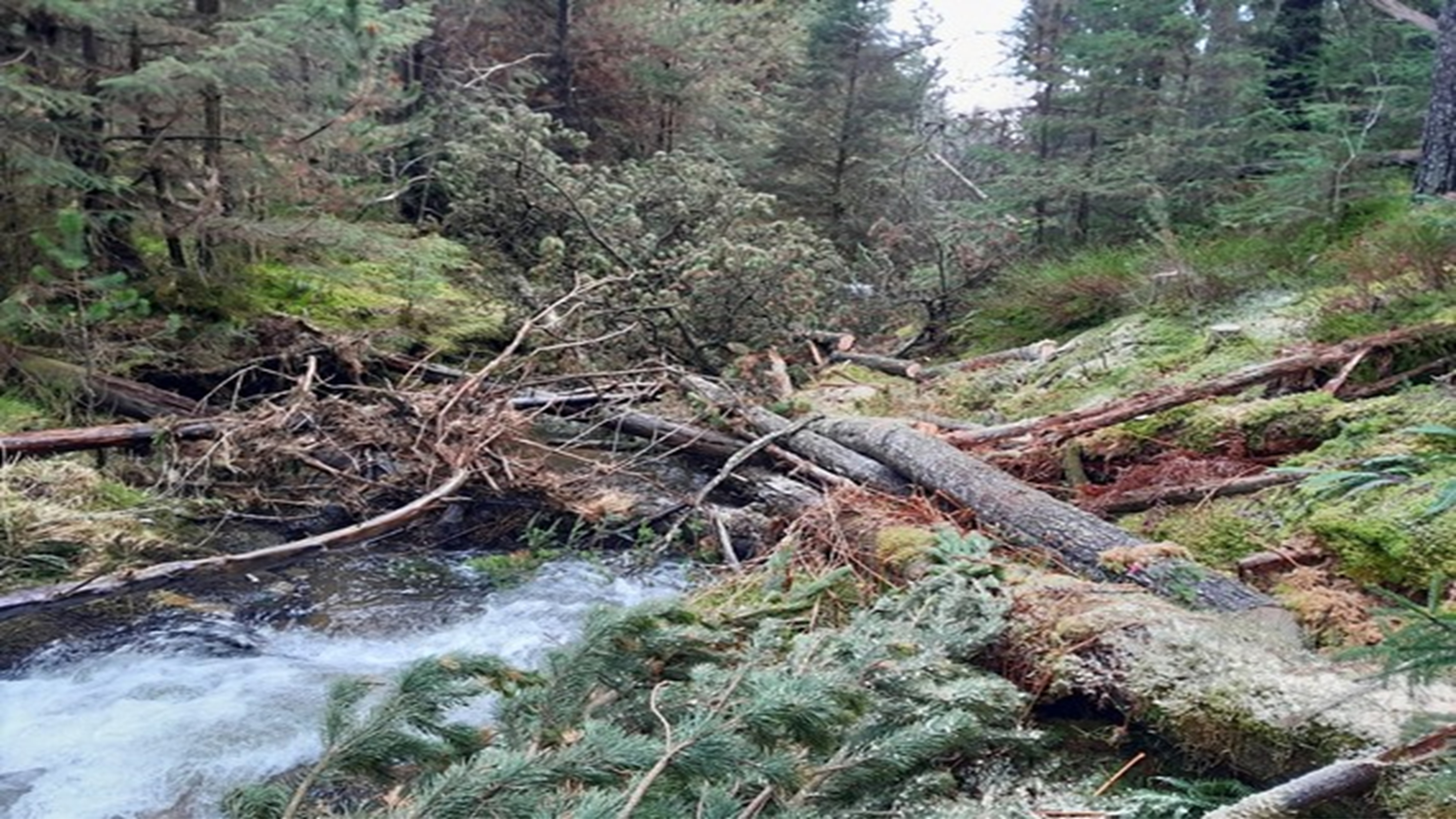
Afon Bidno, Upper Wye Catchment
Our Upper Wye Catchment Restoration Team have undertaken work on the Afon Bidno in the Upper Wye catchment to help slow the flow and provide habitat benefits for wildlife. The work is funded by Welsh Government’s Nature and Climate Emergency Fund, part of the Water Capital Programme. Along a 1.5km stretch of the Afon Bidno in our Welsh Government Woodland Estate, we have placed large deadwood in the watercourse to help slow the water flow and provide a greater variety of river features and habitats for wildlife. The wood also provides food for aquatic insects, and in turn amphibians, fish and otter. We have also partially cut bankside willow trees to encourage the growth of thicker trees which will provide shade for the river, create habitat and slow overland flow. We plan to adopt these same techniques to deliver benefits for water quality and river health on other sites across the Wye catchment and beyond.
Figure 13: Photo showing a leaky dam across the Afon Bidno
Natural Flood Management projects
We have successfully bid for funding from the latest Welsh Government NFM Fund to take forward a project in Dinas Powys. This project contributes to the Welsh Government Programme for Government measure to deliver nature-based flood management in all major river catchments to expand wetland and woodland habitats.
River Cadoxton, Dinas Powys
We have continued our work with the community of Dinas Powys to determine potential NFM options for the catchment. Our engagement officer continues to support the project to seek options which support the wellbeing of people and nature local to the river, its tributaries and the wider catchment. We are progressing more detailed proposals for the implementation of nature-based solutions, and will continue this work in 2025/26. These activities will help nature’s recovery, increase the resilience of communities to climate change and flood risk, and improve water quality.
Natural Flood Management Evidence and Research
We continue to work with partners to understand the effectiveness of nature based solutions in reducing flood risk and providing wider ecosystem service benefits.
In February 2025, the Joint England and Wales (Flood and Coastal Erosion Risk Management) Research and Development Programme published the updated Working with Natural Processes evidence directory. This update provides a new evidence baseline for NFM, and we will use this evidence to inform our approaches.
Where our money is spent
We are funded to deliver FRM work directly by Welsh Government in the form of Flood Defence Grant in Aid (FDGiA) funding. This takes the form of revenue funding which supports routine operational and “business as usual” activities and services as well as capital funding which is utilised to deliver project work.
In 2024/25 NRW received a total of £47m of Welsh Government FDGiA funding to undertake FRM work, this comprised of £24.5m of revenue funding and £22.5m of capital funding. This funding was utilised in this financial year to deliver the FRM outcomes, sustain the services NRW provides and many of the successes outlined in this report.
Capital funding
For financial year 2024/25, our capital budget was £22.5m. We increased protection to 1,032 properties through completing a significant new Capital scheme at Stephenson Street, Liswerry (Newport), another at Sandycroft (Flintshire) and sustained the standard of protection to 856 properties through Capital Maintenance projects.
Alongside the completion of Stephenson Street and Sandycroft, we made significant progress on several major schemes that were at various stages of development during 2024/25. These schemes will form the majority of our future years capital expenditure and include locations across Wales such as Pwllheli and Porthmadog (Gwynedd), Cardigan (Ceredigion), River Ritec, Tenby (Pembrokeshire) and a Taff Catchment Strategic Flood Management Plan (Merthyr, Rhondda Cynon Taff and Cardiff). In the long term, these are expected to benefit over 3,000 properties when they are completed. A breakdown of capital spend by project type is included in figure 14 below:
Figure 14: Pie chart showing the breakdown of Capital spend by project type
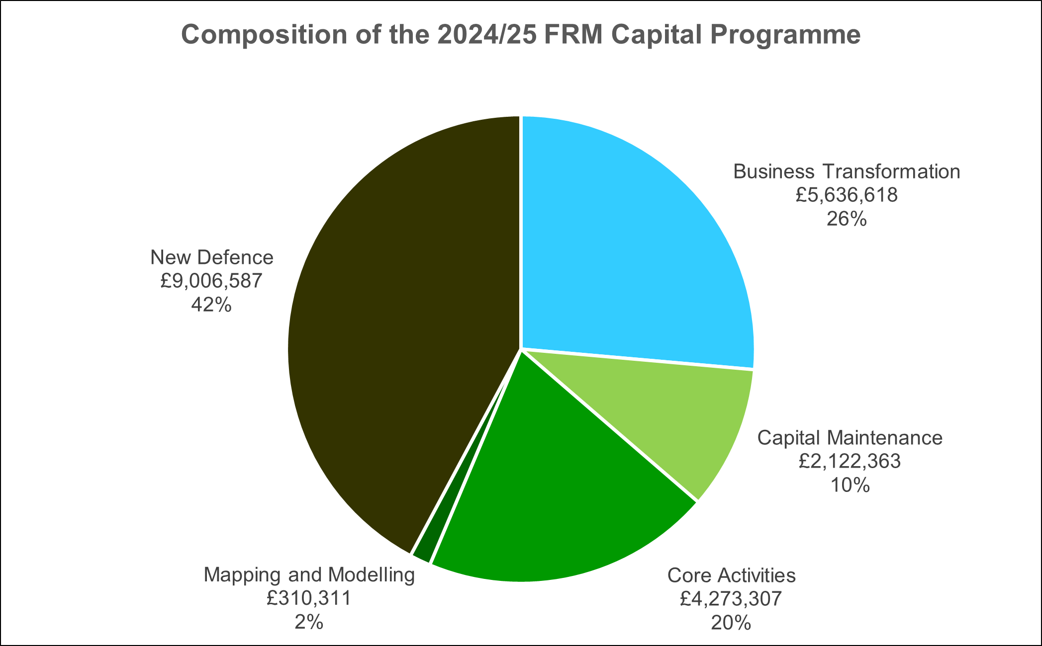
Core Activities include capitalised salary costs (£2.2m), contributions to wider corporate enabling services (£1.8m) and fleet, plant and equipment purchase (£275k). Capital Business Transformation costs relate to FRM specific ICT system development or contributions to system development which benefits FRM services. In 2024/25 this included projects replacing our flood warning system and our telemetry system.
Revenue funding
The 2024/25 revenue settlement of £24.5m supported the significant effort that goes into sustaining and providing the services, advice, tools, and activities NRW undertakes to help manage flood risk in Wales. This funding predominantly supports staff costs, routine maintenance works, various enabling services which support our work and other routine activities. A breakdown of revenue spend by activity is included in figure 15 below.
Figure 15: Pie chart showing the breakdown of revenue spend by activity
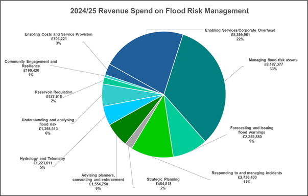
Each of these work areas interact and overlap with each other to deliver key services, therefore there are some areas where teams support wider activities which can misrepresent the scale of effort in some of the above activities as many areas are interdependent on each other to deliver outcomes. For example Hydrometry and Telemetry work heavily supports forecasting and issuing flood warnings.
Enabling Service and Corporate Overheads include FRM’s contribution to the operation of key business services which support the delivery of FRM activities. These include Communications, Procurement, Governance and Leadership, Corporate Planning, Legal Services, People Management, Facilities, Fleet Management and Finance. Service Provision costs are associated with operating and maintaining key systems, tools and services supported by others, for example the Environment Agency.
The revenue budget of £24.5m was fully utilised in 2024/25 and helped support many of the initiatives outlined in this report and ensured that our “business as usual” services continued to be delivered effectively.
Staff numbers
The effort that goes into delivering FRM work within NRW can broadly be grouped into the following work areas and structures:
- National services and policy teams reporting to the Head of Flood and Incident Risk Management within the Evidence, Policy and Permitting Directorate.
- Direct FRM technical services reporting to Flood and Water Management Managers within the Operations Directorate.
- Integrated operational delivery teams reporting to Land and Asset Managers within the Operations Directorate.
- Enabling Services providing central support to all NRW functions are also part funded proportionately by FRM funding to enable the delivery of the services they provide.
As of March 2025, we estimate the FTE staff numbers working directly within the FRM areas identified as per the following table, (this report does not contain data on the number staff working in enabling services as this is too complex to identify specific roles and contributions).
Table 9: Full time equivalent staff posts working directly in FRM as of March 2025 (all posts, including vacant posts)
| Full time equivalent staff numbers | Organisational work area |
|---|---|
| 63.8 | National services and policy teams |
| 143.3 | Direct FRM technical services |
| 172.5 | Integrated operational delivery teams |
| 379.6 | Total estimate of FRM funded FTEs in NRW |
During 2024/25, in response to Grant in Aid budget restrictions, NRW reviewed its staffing structures across the range of activities delivered through Grant In Aid funding. This resulted in decisions to remove funding from various NRW activities, including the removal of £1m of funding to FRM activities from 2025/26 budget onwards. This means that the revenue Grant in Aid from 1 April 2025 will be £23.5m, down from £24.5m This in turn has meant the removal of 18 posts from the structure. As NRW was under a recruitment freeze for much of the last two financial 2 years, the posts removed were vacant posts. Decisions were also made to convert £470k of budget to non-staff budget, to allow greater flexibility on delivery of outcomes. This in turn meant the removal of 9 further posts, with effect from 1 April 2025. As the planning work for this occurred in 2024/25, it is reported in this annual report.
Trends
This chapter is dedicated to showing how the financial year 2024/25 compares to the previous financial years. This is not new data, but amalgamates and summarises the data that is included throughout this FRM Annual Report and previous versions. Like the FRM Annual Report, the trend data is divided into functional topics for ease.
The following trend data is reported for information only without comment. This data will be used to contribute to and help inform business and investment planning decisions within NRW.
Management of flood risk assets – new assets
Table 14: Numbers of properties benefitting from a sustained or reduced level of flood risk
| Year | 2020-21 | 2021-22 | 2022-23 | 2023-24 | 2024-25 |
|---|---|---|---|---|---|
| Properties | 720 | 242 | 1,680 | 1,047 | 1,888 |
Management of flood risk assets – asset inspections
Table 15: Number of routine asset inspections that were completed each year
| Year | 2020-21 | 2021-22 | 2022-23 | 2023-24 | 2024-25 |
|---|---|---|---|---|---|
| Number | 11,810 | 11,061 | 13,571 | 15,725 | 14,289 |
Management of flood risk assets – asset performance
Table 16: Percentage of assets in high risk systems that are at or above their required condition to effectively perform their function
| Year | 2020-21 | 2021-22 | 2022-23 | 2023-24 | 2024-25 |
|---|---|---|---|---|---|
| Percentage | 97.5 | 98.1 | 98.3 | 97.2 | 97.2 |
Reservoir regulation - number of large raised reservoirs and high risk reservoirs
Table 17: Number of large raised reservoirs and high risk reservoirs
| Year | 2020-21 | 2021-22 | 2022-23 | 2023-24 | 2024-25 |
|---|---|---|---|---|---|
| No. of reservoirs | 371 | 395 | 397 | 402 | 405 |
| No. of high risk reservoirs | 188 | 248 | 266 | 269 | 277 |
Advising planners, consenting and enforcement – development planning advice
Table 18: Number of planning consultations where flood risk was identified by the Local Planning Authority as a potential constraint
| Year | 2020-21 | 2021-22 | 2022-23 | 2023-24 | 2024-25 |
|---|---|---|---|---|---|
| Number | 2,086 | 2,353 | 2,414 | 2,352 | 2,100 |
Advising planners, consenting and enforcement – Regulating flood risk activities
Table 19: Number of Flood Risk Activity Permits (FRAPs) and Flood Risk Activity Permit Exemptions granted by NRW in each financial year
| Year | 2020-21 | 2021-22 | 2022-23 | 2023-24 | 2024-25 |
|---|---|---|---|---|---|
| No. of FRAPs | 214 | 285 | 241 | 218 | 204 |
| No. of exemptions | 30 | 52 | 22 | 50 | 46 |
Flood forecasting and issuing warnings - data
Days of elevated flood risk
Elevated flood risk is highlighted through the Flood Guidance Statement which provides a daily flood risk forecast for 5 days to Government and professional partners to assist with strategic, tactical, and operational planning decisions around developing flood risk. The information is also shared with the public through our website.
The figure below shows the flood risk forecast for Wales for each financial year for the past five years. For each year, there is a line for every day of the year, shaded according to the predicted flood risk.
Figure 16: Barcode charts showing the flood risk forecast for Wales for each financial year for the past five years. There is a line for each day with green as very low risk, yellow as low risk, Orange as medium risk and red as high risk.
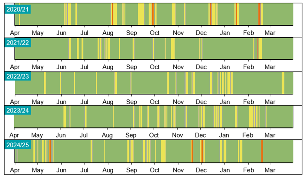
Table 20: Number of days of elevated flood risk
| Year | 2020-21 | 2021-22 | 2022-23 | 2023-24 | 2024-25 |
|---|---|---|---|---|---|
| Days of elevated flood risk (minor forecast impacts and above) | 153 | 121 | 75 | 139 | 102 |
| Days of heightened flood risk (significant forecast impacts and above) | 39 | 15 | 15 | 20 | 40 |
Table 21: Number of flood alerts and flood warning issued each year
| Year | 2020-21 | 2021-22 | 2022-23 | 2023-24 | 2024-25 |
|---|---|---|---|---|---|
| No. of flood alerts | 596 | 369 | 472 | 760 | 622 |
| No. of flood warnings | 195 | 193 | 118 | 196 | 217 |
| No. of severe flood warnings | 2 | 0 | 0 | 3 | 2 |
Table 22: Numbers of properties signed up to Floodline Warnings Direct (FWD)
| Year | 2020-21 | 2021-22 | 2022-23 | 2023-24 | 2024-25 |
|---|---|---|---|---|---|
| Number of properties at risk that are fully registered to receive flood warnings | 52,011 | 49,161 | 48,411 | 47,551 | 48,271 |
Hydrometric network - data
Table 23: Number of rain gauges, level or flow sites and groundwater sites within our network
| Year | 2020-21 | 2021-22 | 2022-23 | 2023-24 | 2024-25 |
|---|---|---|---|---|---|
| Rain gauges | 253 | 253 | 255 | 253 | 253 |
| Level or flow | 340 | 347 | 344 | 334 | 333 |
| Groundwater sites | 139 | 139 | 140 | 135 | 135 |
Community engagement and resilience - data
Table 24: Number of community flood plans in place across Wales that are maintained and fit for purpose and service for the communities that own and use them
| Year | 2020-21 | 2021-22 | 2022-23 | 2023-24 | 2024-25 |
|---|---|---|---|---|---|
| Number | 76 | 74 | 74 | 71 | 76 |
Where our money is spent - data
Table 25: Amount of Capital expenditure in £ millions each financial year
| Year | 2020-21 | 2021-22 | 2022-23 | 2023-24 | 2024-25 |
|---|---|---|---|---|---|
| £m | 13.5 | 17 | 19.5 | 32.1 | 22.5 |
Table 26: Amount of Revenue expenditure in £ millions each financial year
| Year | 2020-21 | 2021-22 | 2022-23 | 2023-24 | 2024-25 |
|---|---|---|---|---|---|
| £m | 21 | 22 | 22.5 | 24.5 | 24.5 |
Other places in Flooding reports, evidence and data
Last updated