
The Arch, near Aberystwyth
Walks through huge beech trees with views over...
Tywi Forest blankets the hills near the small town of Tregaron in one of the most remote parts of mid Wales.
This huge conifer forest was originally planted by the Forestry Commission to produce timber and it remains a working forest.
Our car parks have viewpoints over the spectacular Llyn Brianne reservoir and there is a short waymarked walking trail through woodland to an historic well.
There are also paths and forestry tracks suitable for walking, mountain biking and horse riding – these are not waymarked so you will need a map to explore.
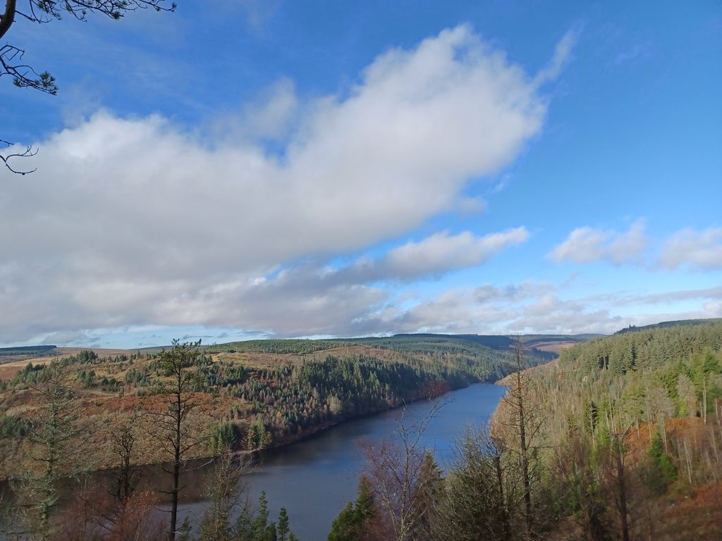
Cwm Berwyn has a car park reached along a forestry track.
The viewpoint looks down the valley towards Tregaron.
Large stone boulders provide informal seating at the viewpoint.
There is a grassy area suitable for picnics near the car park.

There is a short track from the small car park down to a viewpoint at the edge of Llyn Brianne reservoir.
The viewpoint juts out into the reservoir and is a beautiful spot for photographs or a picnic on the grassy bank.

Carreg Clochdy has a large car park with a viewpoint high above Llyn Brianne reservoir.
Large stone boulders provide informal seating to enjoy the views.
There is a grassy area suitable for picnics near the car park.

There is a short waymarked walking trail to an old well.
The trail goes past gnarled oak trees and crosses stepping stones over a river where there is a picnic bench.
The well may have been linked to the nearby Cistercian abbey of Strata Florida – the abbey ruins are managed by Cadw and are open to visitors.

We want you to return home safely after your visit here.
You are responsible for your own safety as well as the safety of any children and animals with you during your visit.
For advice and tips to help you plan your visit here go to Visiting our places safely.
See the top of this webpage for details of any planned closures or other changes to visitor facilities here.
For your safety, always follow instructions from staff and signs including those for trail diversions or closures.
We may divert or close trails whilst we undertake maintenance work or other operations and we may need to close other visitor facilities temporarily.
In extreme weather, we may close facilities at short notice due to the risk of injury to visitors and staff.
You may need permission from us to organise an event or to carry out some activities on our land.
Check if you are allowed to use our land.
Tywi Forest is 10 miles east of Tregaron.
It is on Ordnance Survey Explorer Map 187.
The nearest mainline railway station is in Aberystwyth.
For details of public transport go to the Traveline Cymru website.
There are several car parks in Tywi Forest.
We recommend you follow the directions below or use the Google maps which have a pin on each place’s location.
Parking is free of charge.
Overnight parking is not permitted.
Turn off the B4343 at the Talbot Hotel in the centre of Tregaron and follow the brown and white sign for Llyn Brianne.
Continue along this minor road for 4 miles and the track to Cwm Berwyn car park is on the right.
The Ordnance Survey (OS) grid reference for Cwm Berwyn car park is SN 737 573 (Explorer map 187).
The postcode for Cwm Berwyn car park is SY25 6NN. Please note that this postcode covers a wide area and will not take you directly to the entrance.
View the Cwm Berwyn car park on the What3Words website.
Turn off the B4343 at the Talbot Hotel in the centre of Tregaron and follow the brown and white sign for Llyn Brianne.
Continue along this minor road for 4 miles and go past the track to Cwm Berwyn car park on the right.
Continue for a further 6½ miles and at the junction take the hairpin right towards Llyn Brianne.
Continue for 2 miles, following the shore of the reservoir and the Fannog car park is on the right.
The Ordnance Survey (OS) grid reference for Fannog car park is SN 810 515 (Explorer map 187).
The postcode for Fannog car park is LD5 4TW. Please note that this postcode covers a wide area and will not take you directly to the entrances.
View Fannog car park on the What3Words website.
Turn off the B4343 at the Talbot Hotel in the centre of Tregaron and follow the brown and white sign for Llyn Brianne.
Continue along this minor road for 4 miles and go past the track to Cwm Berwyn car park on the right.
Continue for a further 6½ miles and at the junction take the hairpin right towards Llyn Brianne.
Continue for 2 miles, following the shore of the reservoir and the Fannog car park is on the right.
Continue for a further 1½ miles along this road and the Carreg Clochdy car park is on the right.
The Ordnance Survey (OS) grid reference for Carreg Clochdy car park is SN 812 501 (Explorer map 187).
The postcode for Carreg Clochdy car park is SA20 0PG. Please note that this postcode covers a wide area and will not take you directly to the entrance.
View Carreg Clochdy car park on the What3Words website.
Take the B4343 from Tregaron towards Pontrhydfendigaid.
After 5½ miles turn right, following the brown and white signs towards Strata Florida Abbey.
Continue past the abbey and the road becomes singletrack.
The parking area is a small lay-by on the left after about 1 mile, at the end of the singletrack road – look out for the information panel and please park considerately so as not to block the nearby property’s entrance.
The Ordnance Survey (OS) grid reference for the Holy Well parking area is SN 755 646 (Explorer map 187).
The postcode for the Holy Well parking area is SY25 6ES. Please note that this postcode covers a wide area and will not take you directly to the entrance.
View the Holy Well parking area on the What3Words website.
There are no staff at this location.
Contact our customer team for general enquiries during office hours, Monday to Friday.


