Internal Drainage Districts Boundary Review Consultation
Legal Scheme Submission: Internal Drainage Districts Boundary Alterations
On 9 February 2018, we submitted a Scheme to Welsh Government which will, if confirmed, alter the boundaries of 8 Internal Drainage Districts.
The public now have an opportunity to make representations to the Welsh Government regarding the Scheme. Details of how to make representations are provided in the Notice. The deadline for this is 12 March 2018.
The Cabinet Secretary will consider the Scheme and any representations received. Then, if minded to, the Cabinet Secretary will make an Order confirming the Scheme. NRW will then be able to make changes to drainage rates and special levies accordingly
The Notice and Scheme with maps showing the boundary alterations are available to download below:
- Covering letter to Welsh Government
- Notice
- Scheme
Maps
- Afon Conwy
- Ardudwy Marsh
- Glaslyn and Pensyflog
- Gwent, Calidot and Wentlooge
- Gwent Lower Wye
- Harlech and Maentwrog
- Llanfrothen
- Mawddach and Wnion
- Powysland
NRW previously consulted on the proposed changes to Internal Drainage Districts boundaries. This consultation closed on 17 April 2017. The consultation documents associated with this earlier consultation are provided below for information only. Using the responses received, we refined our proposed boundary changes.
Background and context
Internal Drainage Districts (IDDs) are typically found in low-lying land where a particular need for water level management has been identified. IDD boundaries are determined by physical, not political, attributes and are operated in accordance with the Land Drainage Act (1991).
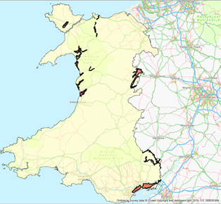
The areas highlighted in black and red on this map show the location of the 14 IDDs within Wales (South Wales Map IDDs, North Wales Map IDDs).
Over time, the use or management of land within an IDD may change and land parcels that once needed to be part of an IDD may no longer be suitable, and vice versa. In light of this, NRW has conducted a review of the current boundaries of the 14 IDDs within Wales with a view to making revisions to those boundaries where appropriate.
It was decided early in the review to exclude Borth Bog IDD from the review due to ongoing studies into the management of Cors Fochno, a UNESCO biosphere reserve, Site of Special Scientific Interest and Special Area of Conservation which is within Borth Bog IDD.
Additionally, during review, it was decided that revisions were not necessary in the following three IDDs so they are also excluded from this consultation: Dysynni IDD, Malltraeth Marsh IDD and Tywyn IDD. The decision to exclude these three IDDs comes after careful consideration of how these IDDs operate. If you do wish to make any comments in relation to these IDDs, please use the contact information at the bottom of this page.
This consultation therefore proposes revisions to 10 IDD boundaries: Afon Conwy IDD; Afon Ganol IDD; Ardudwy Marsh IDD; Caldicot & Wentlooge IDD; Glaslyn & Pensyflog IDD; Harlech & Maentwrog IDD; Llanfrothen IDD; Lower Wye IDD; Mawddach & Wnion IDD; Powysland IDD.
Duration of consultation
This consultation will run for a duration of 6 weeks from 6th March 2017 to 17th April 2017.
Consultation documentation
The package of documents includes a consultation document report for each of the ten IDDs with proposed revisions; pdf maps that show the revisions in greater detail; and a glossary to explain any terms you may be unfamiliar with.
Afon Conwy IDD boundary review consultation report
Afon Conwy IDD Maps - Main Map, Map 1, Map 2, Map 3, Map 4
Afon Ganol IDD boundary review consultation report
Afon Ganol IDD Maps - Main Map, Map 1, Map 2
Ardudwy Marsh IDD boundary review consultation report
Ardudwy Marsh IDD Maps, Main Map, Map 1, Map 2, Map 3, Map 4
Caldicot & Wentlooge IDD boundary review consultation report
Caldicot & Wentlooge IDD Maps – Main Map, Map 1, Map 2, Map 3, Map 4, Map 5, Map 6, Map 7
Glaslyn & Pensyflog IDD boundary review consultation report
Glaslyn & Pensyflog IDD Maps - Main Map, Map 1, Map 2
Harlech & Maentwrog IDD boundary review consultation report
Harlech & Maentwrog IDD Maps - Main Map, Map 1, Map 2, Map 3, Map 4
Llanfrothen IDD boundary review consultation report
Llanfrothen IDD Maps - Main Map, Map 1, Map 2
Lower Wye IDD boundary review consultation report
Lower Wye IDD Maps - Main Map, Map 1, Map 2, Map 3, Map 4, Map 5, Map 6, Map 7, Map 8, Map 9
Mawddach & Wnion IDD boundary review consultation report
Mawddach & Wnion IDD Maps - Main Map, Map 1, Map 2
Powysland IDD boundary review consultation report
Powysland IDD Maps - Main Map, Map 1, Map 2, Map 3, Map 4, Map 5, Map 6, Map 7, Map 8
Consultation results
A report detailing the results of our IDD boundary review consultation can be downloaded below. It includes a summary of comments and queries we received in the consultation response forms, and details how our proposed changes to the IDD boundaries have taken these responses into account. The report outlines the next steps we will take with the Welsh Government to implement our proposed changes.