Porthmadog Flood Risk Management Project

Credit: NPAS (National Police Air Service)
Managing flooding in Porthmadog
Natural Resources Wales (NRW) is exploring options to more effectively manage the long-term flood risk to Porthmadog and surrounding communities. We are keen to explain about the long-term flood risk to the community and how this project provides an opportunity to address these risks. We will also be looking for wider environmental, social, and economic opportunities.
Flood Risk in Porthmadog
The community of Porthmadog and Tremadog is at risk from flooding from rivers and the sea. As our climate changes, it is anticipated the area, like many other communities across Wales, will face more frequent storms and heavy rain as well as rising sea levels. Maintaining current levels of flood protection to people and homes will be a challenge given the area’s low-lying land and the aging flood defences in place.
Our Work
The project builds on previous projects and studies and will involve assessing a range of long-term options to reduce the risk of river and sea flooding to the local community. We will take into account a range of factors for the options we consider such as sustainability, viability, and affordability. We are committed to working with nature and exploring opportunities to create new habitats and improve the biodiversity in the area. There may be opportunities to regenerate the existing flood defences and associated public spaces, providing wider benefits for the local community. We want to work together to find solutions that can offer a sustainable future for Porthmadog.
Any decision about the future of flood defences within Porthmadog and Tremadog will take into account the West of Wales Shoreline Management Plan (SMP). The SMP provides the framework for managing long-term impacts of coastal flooding and for Porthmadog, it recommends a policy of ‘Hold the Line’ over the next 100 years. Hold the line is an aspiration to build or maintain artificial defences so that the current position of the shoreline remains. This is subject to affordability and can involve changing standards of flood protection.
Throughout 2022, we updated our flood model to better understand the risk of flooding. Using the latest guidance, available river flow records and photographs taken during the winter of 2015, we are able to predict present and future flood risk considering the increased pressures from climate change. The model shows a greater number of homes and businesses at risk from the Afon Glaslyn, Y Cyt and from the sea. This concerns us all, and that is why NRW is focused on finding sustainable solutions to manage the risk.
Consultation feedback
During January and February 2023, we carried out public consultation on the updated flood modelling outputs and possible long-list options. The information boards presented during the consultation can be viewed and downloaded in this virtual room.
Specific consultation days were arranged at the Y Ganolfan Community Centre on 26 and 27 January and this event was advertised by a postal newsletter which was delivered to 2476 addresses. This was well attended with a mix of key stakeholders, and local residents. There was a registered total of 67 attending on Thursday 26 January and 59 attending on Friday 27 January. A further 13 people were counted on the clicker across both days but did not register on arrival. Making a total of 139 attendees. There was a low response from businesses, local landowners, and from farmers.
A feedback form was available to everyone on the NRW consultation hub webpage and also via Virtual Engage. Hard copies were also handed out during the event with self-addressed freepost envelopes. A total of 27 forms were returned – 23 English and 4 Welsh. Of the 23 English responses, nine were postal, 13 were online. For the four Welsh responses, two were postal and two were submitted online.
The feedback received during the event, is summarised as follows:-
- All long list options received votes, with many respondents selecting all options in their responses. The three options that received the greatest amount of support (59%) were: ‘Upgrade River Defences’, ‘Watercourse Improvements’, and ‘Pumping Solutions’, followed closely by: ‘Upgrade Coastal Defences’ and ‘Property Level Protection’ at 52%. The ones that received the least support were to ‘Reconfigure Coastal Defences’ and ‘New Flood Warning Area’, which were at 26% and 22% respectively.
- When asked ‘what do you value most about the environment in Porthmadog?’ ‘Wildlife and Nature’ was the most popular answer with 67%. This was followed by ‘Landscape and Scenery’ and ‘History and Culture’ which were both selected by 59% of respondents, compared to 37% who chose ‘Recreational Opportunities’.
- When asked ’How does flooding affect you in the Porthmadog Study Area?’ the majority were concerned with flooding to homes (14), and the impact on businesses and wider socio economics (7). There were 4 comments concerning house and business insurance.
- When asked ‘why they had selected the longlist options’, there were mixed responses as to the number of options being proposed. Some thought it was important that all options are considered. Others thought that the number of options suggested a lack of viable solutions. Comments under the ‘other options’ section showed a lack of confidence that NRW could deliver the project, and that sufficient funds would not be made available.
- When asked ‘if you have any concerns with the longlist options’, some respondents suggested alternative options be proposed. This included dredging of the harbour, constructing additional outfalls to increase capacity and the facilitation of tidal energy. The main concern was cost and lack of funding (5). There was also some scepticism regarding the maps illustrating flood risk cover.
Latest Project News
During 2023 and 2024, we have been reviewing the findings from our flood model and using community feedback to develop a list of possible scheme options to reduce flood risk to people and homes. This has included the following:
- Extensive flood modelling
- Carrying out new environmental surveys as part of evidence gathering
- Holding individual meetings with community and technical stakeholders
- Consulting with Statutory Bodies
- Seeking feedback from civil engineers and technical specialists
- Working with local partners to gather lived experiences and insights
- Continuing discussions and visiting local Porthmadog Schools (Higher and Lower), working with the NRW education team.
Using the evidence and feedback gathered to date, and working with stakeholders, we are appraising a long-list of options to form a proposed draft Short List. This process involves considering the long-term effects of sea level rise, climate change, value for money, and legal and technical viability and has taken longer than we had hoped. We plan to share the draft assessment findings and the draft recommended Short List of options, for further consideration with the community, in 2025.
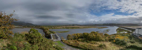 View of the Afon Glaslyn, Llyn Bach and the Cob
Keeping in touch
We will provide project updates on this webpage.
Please get in touch if you would like to find out more and to share your views with us as well as to register for future progress updates:
Email: porthmadog.floodrisk@grasshopper-comms.co.uk
Tel: Andrew Basford, Project Manager (Welsh Learner) on 03000 65 3846 or Sharon Parry, Project Team Support Officer (Welsh Speaker) on 03000 65 5264.
You can also write to us at:
Sharon Parry
Natural Resource Wales
Bangor Office,
Maes y Ffynnon,
Gwynedd,
LL57 2DW