
Beddgelert Forest, near Beddgelert
Huge forest in the heart of Eryri (Snowdonia)...

Current trail diversions
The Tarw Du mountain bike trail is diverted as the R74 section is closed.
Please follow all on-site signage and diversions.
Please check the Coed y Brenin Facebook page for the latest information.
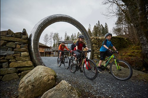
Coed y Brenin was Britain's first purpose-built mountain biking centre and it is still one of the sport’s top destinations.
Eight purpose-built mountain bike trails start from the visitor centre and range from easy trails for families and beginners to technical routes for expert riders. Other facilities for mountain bikers include a bike shop and a skills area where you can develop your riding techniques.
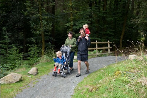
The visitor centre is the starting point for walking and running trails through Coed y Brenin Forest Park as well as orienteering courses and geocaching trails.
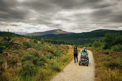
Two of the walking trails are suitable for visitors using an off-road mobility scooter.
There are also children’s play areas, a café and plenty of picnic tables.
These three walking trails start from Coed y Brenin Visitor Centre car park.
More walking trails start from our other car parks within Coed y Brenin Forest Park.
The walking trails are waymarked from start to finish.
Look out for the information panel at the start of the trail.
Find out about walking trail grades.
Follow the accessible trail down through woodlands to the riverside picnic site where the Afon Eden river rushes over the rocks.
Pick up an animal puzzle trail leaflet from the visitor centre and let younger visitors follow the clues.
You can also download an audio trail and listen to the story of the forest’s wildlife and history.
If you would like to use the Dolgefeiliau accessible parking area near the picnic area, please contact the visitor centre for directions.
You can hire a Tramper off-road mobility scooter from the visitor centre. Please note that this must be booked in advance by contacting the visitor centre.
Audio trail
Find out about the wildlife, trees and history of Coed y Brenin Forest Park on our mp3 audio trail.
It has been designed for use on the Afon Eden Trail and starts from the car park.
There are numbered posts on the walking trail which tell you when to play each section.
As mobile phone network coverage can be limited in rural areas, we recommend that you download the audio trail before your visit.
You can also download a PDF file of the script.
To download the audio trail go to Audio trails and folk tales.
Try this beautiful route for all the family to the Cefndeuddwr viewpoint and picnic area.
From there, take in the panoramic views to Y Garn and the Rhinogydd mountains.
If you would like to get to the accessible parking area at the viewpoint please ask for a key and directions at the visitor centre.
You can hire a Tramper off-road mobility scooter from the visitor centre. Please note that this must be booked in advance by contacting the visitor centre.
The Gain Waterfall Trail climbs over the Cefndeuddwr ridge before dropping into the next valley and descending to the confluence of the Afon Gain and Afon Mawddach rivers with their twin waterfalls.
This is a tough circular walk that follows a combination of forest roads and steep footpaths on an unmade and uneven surface.
Please stay on the waymarked trails as the old mine workings and buildings may be unsafe and there are unprotected drops into the river gorges.
Two of the walking trails (Afon Eden and Cefndauddwr) are suitable for visitors using an off-road mobility scooter.
One goes down to the riverside picnic area and the other goes uphill to a viewpoint with picnic table.
You can hire a Tramper off-road mobility scooter from the visitor centre. Please note that this must be booked in advance by contacting the visitor centre.
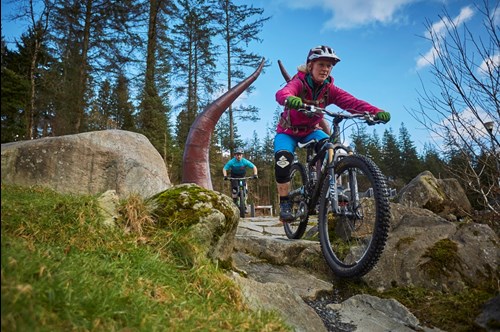
All our mountain bike trails are waymarked from start to finish and have been graded for difficulty.
At the start of the trail there is an information panel – please read this before setting off.
This forest road trail takes in some of the most picturesque parts of the river Mawddach including the beautiful waterfalls on the river Gain and Mawddach.
It’s a relatively low level route on forest roads but does include a rougher section of private track.
There are a couple of short steepish climbs and a steep forest road descent.
This trail is a great fun introduction to mountain biking for a wide range of ages and abilities.
There are plenty of fun features including stone steps, rollers, table tops, berms and the occasional jump.
There are short steep climbs and a rough forest road descent.
The trail is built in four loops which get progressively longer and more challenging.
The first three loops can be used by disabled riders using adaptive mountain bikes.
Loop 4 uses a rougher section of private track up to the waterfalls with a barrier to negotiate.
Accessibility information
This trail is suitable for people using adaptive equipment.
Adaptive equipment includes adaptive cycles, adaptive wheelchairs and mobility scooters.
We have produced a film about this trail to help you work out how suitable it may be for you before you visit.
To watch the film, go to Trails for users of adaptive equipment
If you want to try the more challenging trails at Coed y Brenin, then this short but technical trail is a great introduction to show you what’s in store.
It’s tough right from the start with rock slabs and steps.
It includes some red and black grade features and a long hard forest road climb.
If you can handle this, then you’ll love our other trails.
Cyflym Coch is ideal for those riders who have mastered the MinorTaur and want to move up to the next grade.
The trail strings together some of the best fast flowing sections in the forest park, with relatively short climbs.
With sections like Dream Time and Uncle Fester it’s a real blast!
Here’s one of those understated, quietly classic trails that always seems to surprise you at just how good it is.
The hard start leaves you under no illusions that your skills better be up to scratch, but then leads you into the sublime DreamTime where the flow feels so easy, you’ll be day dreaming about this throughout the week’s daily grind!
Big Doug leads you through the towering Douglas Firs, the kings of Coed y Brenin.
Ride Hermon as fast as you dare, before the big climb to the highest point in the forest.
The five sections of downhill fun in the Adams Family reward you for all your efforts.
This trail is a real favourite; with a great mix of rocky gnarlyness, fast, flowing singletrack and new style features and sections.
You’ll be riding over bedrock, negotiating loose, rocky, climbs and descents, swooping round berms, finding a rhythm over huge rollers, flying down steps, dropping into the ‘Cavity’ and getting spat out the exit with as much style as you can muster!
This is a severe trail with unavoidable fly-offs, so be sure that your skills are up to it.
The Tarw Du, which is Welsh for black bull, is the original trail at Coed y Brenin and is widely regarded as the first purpose-built mountain bike trail in the UK and probably beyond.
It’s rocky, it’s retro and the new section (Y Slab) features several large slabs and some committing features.
This is the trail that everyone aspires to ride.
It’s long and it’s tough, and it will stretch you both physically and mentally.
You can expect loose rocky climbs, gnarly descents, stone fly offs, berms, tabletops and hips.
Don’t miss the Pink Heifer, Big Doug combo that gives over 4 kilometres of continuous sublime singletrack through the majestic tall Douglas firs.
Will you be dragging yourself up the final climb, limping down the last descent utterly spent, or will you rise to the challenge and tame the Beast?
Y Ffowndri skills area has examples of the features found on different levels of graded mountain bike trails.
There are training areas for new riders to learn and develop riding techniques.
It is also a great place for more experienced riders to warm up or wind down after a ride.
If you’re new to mountain biking or want to learn off‑road riding techniques the Training Zone is the place to start.
If you’re new to Coed y Brenin and not sure which grade of trail to ride head to the Singletrack Zone to see what you are capable of.
There are four grades of trail here from easy (green) to severe (black).
Start easy and progress until you find your level.
The Freeride Zone is a jump/pump track for mountain bikes.
It has eight bermed turns with fun features including rollers, hips, doubles, table tops and step ups/downs.
The Drop-off Zone features the Lemming Stone, a natural rock slab, where a variety of lines can be taken but remember to look before you leap.
You need to ride the red singletrack before you access this area.
Y Ffowndri Skills Area was built as part of the Eryri Centre of Excellence Project which was part-funded by the EU’s Convergence European Regional Development Fund through the Welsh Assembly Government.
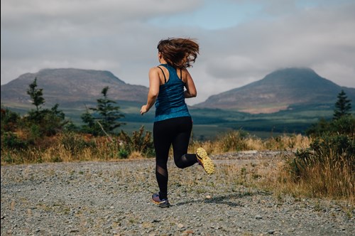
Five waymarked running trails leave from the visitor centre and go through some of the best scenery in Coed y Brenin Forest Park.
The trails vary in length and have been designed for novice to more experienced runners.
They include a mixture of singletrack, forest roads, rough unmade public rights of way and occasional sections of tarmac road.
Be prepared for roots, mud and rocks with steep ascents and descents.
A short route, ideal for younger runners and those trying out new running shoes.
Climb up onto and contour round the Cefndeuddwr ridge, where you’ll meet the Sarn Helen, a Roman road, before descending back to the visitor centre.
After climbing up to the Cefndeuddwr ridge, begin a descent into the valley.
Follow the Afon Gain river upstream to the ruins of Penmaen Farm where the trail climbs back up the hillside to the Sarn Helen, a Roman road.
Return past the medieval ironworks and along the forest road to the visitor centre.
The trail climbs over the Cefndeuddwr ridge, where it detours along two footpaths before descending to the Afon Mawddach river.
After crossing the aerial bridge at Tyddyn Gwladys, you’ll climb up to and cross the Copper Bog before descending past Cae’n y coed house.
Join a bridleway back down to the Afon Mawddach river, then follow a low level finish along the Afon Eden river back to the visitor centre.
Once you’ve climbed to the Cefndeuddwr ridge, descend on forest roads to the Afon Mawddach river, following the river downstream.
Climb the next hill, along the edge of the copper bog and then down again on a footpath to the valley of the Afon Wen river.
The trail then climbs up past Ceunant Hyll and its cascading stream.
As you follow the extreme eastern edge of the forest park, you can enjoy some unexpected views.
Then descend back to the Afon Wen, taking in a short section of tarmac road.
You’ll have a chance to catch your breath, as you follow the valley floor round the end of the hill to the Afon Mawddach.
There’s one final sting in the tail after Ty’n y Groes: a climb back over the Cefndeuddwr ridge to the visitor centre.
Hunt for the geocaches hidden in the forest on one of the two geocaching trails from the visitor centre.
Each geocache is a small container with a log book to record your visit.
The geocache may also contain small items left by other visitors that you can swap for something you have brought with you.
The geocaching trails are designed for walkers and there is no access for vehicles or bikes to the geocache sites.
Test your map reading skills by navigating between the controls (wooden marker posts) on an orienteering course through Coed y Brenin Forest Park.
The four permanent orienteering courses start and finish at the visitor centre.
They were designed by the Mid-Wales Orienteers and are all graded to British Orienteering Federation standards.
To get started download the maps from the bottom of this page or buy an A3 waterproof map (1:7,500 scale) from the visitor centre when you arrive.
The entire course can be completed on good paths.
This course is harder than the yellow course.
It has controls on or close to line features as well as paths and allows you to develop your navigational skills.
The red course's navigation is moderate and it has route choices.
You will need to use line features other than paths (for example, walls) as “handrails”.
You will need to venture a short way from line features in one or two places.
This course's navigation is harder than the red course and it has route choices.
Some controls are on point features which are some way from any line feature.
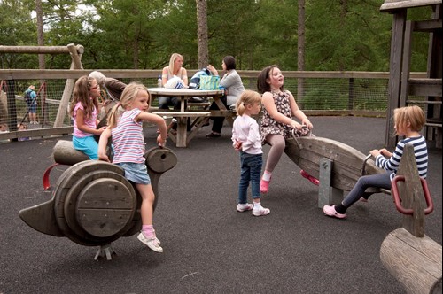
The play areas are next to the visitor centre and are divided into areas suitable for children of different ages.
The facilities include:
The lower play area has a range of accessible play equipment and the ground is covered by a soft pore surface.
The rotating rock apparatus offers a natural play opportunity. It is stimulating, light and easy to operate as it requires minimal arm strength to activate it.
The bird’s nest swing is easily usable and safe for children who find it difficult to sit up or use conventional swings.
The “see saw” type apparatus is an inclusive design which meets the needs of many children particularly wheelchair users as it has a ramped entrance and exit and offers the thrill of the changing surface.
The free play area uses natural features such as stepping stones, logs, branches for den building, fruit trees and a small stream.
Supervised play on these features offers an opportunity for children to play and explore, helping them to develop important skills in a more natural area while still having fun.
The free play area helps children to develop their understanding of the natural environment where some hazards remain to be experienced and an inherent sense of risk remains.
Children can benefit by developing risk management, co-ordination, balance, and problem solving skills through the fun of play.
Pick up an animal puzzle trail leaflet from the visitor centre and head for the Afon Eden walking trail.
Then follow the clues, keeping your eyes peeled for the animals.
You can get a discovery backpack from the visitor centre.
Each backpack contains useful goodies like binoculars, a magnifying glass, a bug pot and nature identification cards along with a guide explaining how to use them.
The café in the visitor centre has views over the valley and forest park.
You can sit indoors or outside on the large balcony.
The café serves hot and cold food (with vegetarian and vegan options), a choice of coffees, other drinks and cakes.
Dogs on a short lead are welcome in the café.

Coed y Brenin Visitor Centre's conference facilities are suitable for a variety of business meetings, events and activities.
Find out more about conference facilities at Coed y Brenin Visitor Centre.
Beics Brenin bike shop is situated in the lower level of Coed y Brenin Visitor Centre.
Beics Brenin offers:
For more information and opening times go to the Beics Brenin website.
Coed y Brenin Visitor Centre has been awarded the Visit Wales Gold Award.
This award is given to attractions that make an exceptional effort to create an enjoyable and memorable experience for visitors.
Explore Coed y Brenin on a waymarked walking trail from one of our other car parks in the forest park:
Coed y Brenin Forest Park is set in Eryri (Snowdonia) National Park.
Eryri is the largest National Park in Wales and is home to picturesque towns and villages and the highest mountain in Wales.
It is looked after by the Eryri National Park Authority.
For more information about visiting Eryri go to the Eryri National Park Authority website.
Coed y Brenin Forest Park forms part of the National Forest for Wales.
The National Forest will:
It will form a connected ecological network running throughout Wales, bringing social, economic and environmental benefits.
Parts of the network will eventually form a trail running the length and breadth of Wales, so anyone can access it wherever they live.
For more information go to the National Forest for Wales website.
We want you to return home safely after your visit here.
You are responsible for your own safety as well as the safety of any children and animals with you during your visit.
For advice and tips to help you plan your visit here go to Visiting our places safely.
Facilities for visitors with disabilities at Coed y Brenin Visitor Centre include:
There are also accessible trails from three of our other car parks in Coed y Brenin Forest Park:
Follow the links at the bottom of this page to find out more about visiting these places.
The visitor centre, shop and café are open Monday to Sunday 10am to 4pm.
They are closed Christmas Day, Boxing Day and New Year's Day.
Please check the top of this webpage for any changes to these opening times or check the Coed y Brenin Facebook page for the latest information.
See the top of this webpage for details of any planned closures or other changes to visitor facilities here or check the Coed y Brenin Facebook page for the latest information.
We may divert or close trails whilst we undertake maintenance work or other operations and we may need to close other visitor facilities temporarily.
For your safety, always follow instructions from staff and signs including those for trail diversions or closures.
In extreme weather such as snow, ice or high winds:
Coed y Brenin Visitor Centre is 8 miles north of Dolgellau.
The postcode is LL40 2HZ.
Follow the signs to the visitor centre - do not take the no through road.
Please see the directions below or use the Google map on this page which has a pin on the car park’s location.
The visitor centre is signposted from the A470.
From Dolgellau, take the A470 towards Porthmadog.
Go through the village of Ganllwyd, continue for 1½ miles and the entrance to the visitor centre is on the right.
View this place on the What3Words website.
The Ordnance Survey (OS) grid reference for the car park is SH 723 268 (Explorer Map OL 18).
The nearest mainline railway stations are Barmouth (Cambrian Coast line) and Blaenau Ffestiniog (Blaenau Ffestiniog-Llandudno line).
Bus services from Dolgellau and Blaenau Ffestiniog will stop by request at the entrance road to the visitor centre on the A470.
For details of public transport go to the Traveline Cymru website.
Overnight parking is not permitted.
You are charged for the length of time you park at Coed y Brenin Visitor Centre.
You pay the parking charge when you are ready to leave.
The charges are:
Pay the charge at the exit barrier by card or contactless as you drive out.
Alternatively you can enter your registration number at one of the machines in the car park and pay by cash, card or contactless - the exit barrier will then lift automatically as you drive out.
Please note that the machine at the exit barrier only takes payment by card or contactless.
An annual season ticket is on sale at the visitor centre reception.
Car parking is free if you live within the LL40 or LL41 postcode or the neighbouring villages of Arthog, Cutiau, Cardeon, Corris and Tal-y-Llyn.
Take your vehicle log book (V5 document) to the visitor centre welcome desk to register for free parking.
Car parking is free for Blue Badge holders.
On departure from the car park, scan your Blue Badge at the exit barrier and the barrier will lift.
There is free parking for bicycles in the cycle rack in front of Beics Brenin (the onsite bike shop).
Sixteen free charging points for electric bikes have been installed outside the visitor centre.
The chargers are 13 amp and have weatherproof sockets.
Locks for bikes are available from Beics Brenin.
coedybrenin@cyfoethnaturiolcymru.gov.uk
Coed y Brenin Visitor Centre, Dolgefeiliau, Dolgellau LL40 2HZ


